|
Four themes are employed in this
account of developments in the Dunmurry area between
1900 and 1960.
The contents of each theme are
presented chronologically and they are accompanied
by additional information to provide further
insights and perspectives.
I thank my wife and daughter for
their support in the preparation of this work. I am
also grateful for the assistance I again received
from my publisher.
This publication has been
assisted by Lisburn City Council.
I acknowledge permission received
from the Public Record Office of Northern Ireland to
draw upon information among its sources.
My thanks are also made to the
Controller of H.M.S.O. at Norwich for the use of
population data in the 1901, 1911, 1926, 1937, 1951
& 1961 General Reports.
R.
Common
November
2003
Typeset by Island Publications
Printed by Regency Press, Belfast
1:
People and Place
Introduction
Just as Lisburn stands at a favourable location
between the Middle and Lower Lagan valley, so, too,
Dunmurry is situated at the threshold of the easiest
routeway to and from Belfast Lough. The site of Dunmurry
village on a low interfluve between the Derriaghy and
Glen burns also proved to be advantageous, for both
transverse as well as longitudinal movements within the
lower Lagan valley. Much of Dunmurry and Seymour Hill
have been built on ground lying between 40m and 20m in
this valley plain. Diversity in local relief does occur,
however, because of incised tracts along the Derriaghy
and Glen burns between 30.5m and 15.5m. There are also
limited swells on the ground that rise above 40m at
Rathmore, The Park, Dunmurry motte and Conway.
Surface deposits in the 3 km wide
valley plain about Dunmurry are of glacial or fluvial
origin. Hill foot slopes to the west begin at c 50m and
quickly rise to a dissected scarp of Tertiary basalt at
100m. To the east rolling hillocks, based on Silurian
sediments, rise about 50m beyond the undulating ground
that flanks the valley plain. (See Figure 1.)

Fig. 1 Some features
of the lower Lagan valley
1. R. Lagan. 2. Main
railway. 3. Selected railway
stations: B. Belfast; D. Dunmurry;
L. Lisburn. 4. Important roads: a)
Belfast-Lambeg (B102); b)
Belfast-Drumbeg (B107); c)
Belfast-Lisburn (A1); d)
Lisburn-Knock (B205). Longstanding
transverse roads: t'
Balmoral-Stockman's Lane; t2
Dunmurry Lane-Suffolk; t3
Drumbeg-Lambeg.
Currently the growing season about Dunmurry averages
230 to 250 days in the year, but it soon drops to about
220 days on the higher ground to the west. Relief also
affects rainfall totals over the year with ground over
150m recording 1000-1200mm annually, in contrast to the
9001000mm on the valley floor. In the temperate, oceanic
climate snowfall is short lived on the low ground
between December and March while the highest
temperatures there occur between May and August.
The continuity of human occupance
hereabouts is a long one and certainly goes back to
Neolithic times (c 3000 B.C.). Since then a succession
of residents in the district, from Bronze and Iron Age
periods as well as Norman and Plantation times, have
left scattered reminders of their former presence. The
landscape has been gradually modified from woodland to
crop and grassland, firstly for subsistence, mixed
farming and then for commercial agriculture. In step
with these changes came the development of dispersed and
then nucleated settlements containing residents with
close interdependent relationships at first and then
widening contacts elsewhere with the passage of time.
Locally grown flax, available water
supplies', market demands and the business acumen of
certain families fostered change in the local economy
during the 181h century. These entrepreneurs then
promoted the 19th century development of
industrialized textile enterprises in the district and
the transformation of Dunmurry itself into a commercial
"linen village'.
The 20th century, by
contrast, has seen the decline of local textile
businesses and readjustments to the types and places of
employment for residents. Fortunately a congenial
environment, easy access to places of work in Belfast
and Lisburn have offered some compensations. The
availability of "green field" sites, for example, have
proved to be extremely attractive for "overspill"
housing developments and for "footloose" industries in
the years following World War II. Inevitably another
transformation has been taking place, gradually changing
the village and parts of adjacent townland areas into a
suburban district – increasingly subject to official
influences from both Belfast and Lisburn.
In spite of the changes outlined the
presence and recognition of townlands has persisted both
locally and provincially. Townlands were traditional
land units, established in pre Norman times. They
designated land which was formerly worked by several
families to satisfy their basic needs. Their areas
reflected the productivity of the land, as well as the
populations involved. In 1911 the local townland areas
were as follows: Dunmurry 329 hectares (ha), Derriaghy
236 ha, Killeaton 96 ha, Kilmakee 136 ha and Poleglass
163 ha. By 1951 Dunmurry, Killeaton and Kilmakee covered
the same areas but Poleglass and Derriaghy had changed
officially.
Population
By 1900 about 75% of the population in Dunmurry
townland lived within the village, but 60 years later
90% resided there. In the same period the percentage
distribution of houses present in the village also
changed from 76% to 90%. Unlike neighbouring townlands
Dunmurry experienced considerable and sustained
population growth, in spite of economic changes. Over
this 60 year period females were more numerous than
males in the district. Dwellings to house the growing
population increased by four times over these years
while the average number of residents in a household
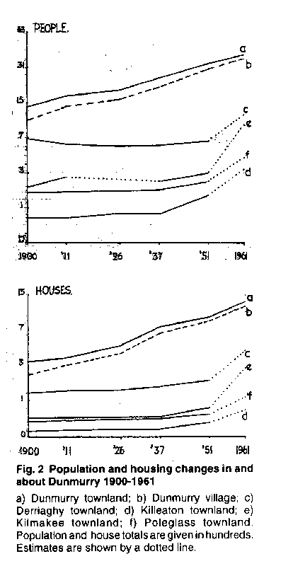
declined from 4.8 to 3.6. (See Figure 2.)
The average annual growth of
population in Dunmurry was gentle until 1926 when the
pace quickened to a moderate rate until the end of World
War II. Subsequently the average growth rate became
rapid until 1961 when it began to ease off. Back in 1900
the birthplaces of residents indicated that 59% of them
were in Co. Antrim and 17% in Co. Down. Belfast and
Dunmurry had become the primary birthplaces of residents
by 1960, however, together with a much wider spread from
other places either within the province or from
elsewhere.
Nearby population totals declined
slightly in Derriaghy townland between 1900 and 1926
before rising in subsequent years, and especially after
1950. The male to female ratio amongst residents has
remained steady and almost evenly balanced. House
numbers increased gradually until after 1951 when a
rapid growth of dwellings occurred and the average
numbers of residents per household declined from 4.8.
In the first three decades of the
20th century population numbers were very low in
Killeaton townland but subsequent growth has been
noteworthy. Records indicate that male residents
consistently outnumbered females and for many years four
was the average number of residents per household.

Fig. 2 Population
and housing changes in and about
Dunmurry 1900-1961
a) Dunmurry
townland; b) Dunmurry village; c)
Derriaghy townland; d) Killeaton
townland; e) Kilmakee townland; f)
Poleglass townland. Population and
house totals are given in hundreds.
Estimates are shown by a dotted
line.
Kilmakee townland experienced small changes in
population and house numbers until 1937, after which
significant increases began to occur. The male to female
ratio in this townland swung in favour of males after
that date while the average number of persons per
household fell below 4.
Poleglass townland showed population
and household characteristics similar to those displayed
by Derriaghy but on a smaller scale. (See Figure 3.)
The density of population in Dunmurry
townland trebled between 1901 and 1961 to levels well
above those in nearby townlands. While population
densities in Derriaghy and Poleglass did not vary
greatly over this period both Killeaton and Kilmakee
showed marked density increases after 1951, related to
the inward movement of people.
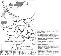
Fig. 3 Selected items of note in the
Dunmurry area
- R. Lagan (here a county
boundary)
- Dunmurry townland, with the
location of some adjacent townlands
named
- Railway, with the location of
Dunmurry station provided
- Steep slopes of 12º
and over
- Colin Glen
- Lagmore Reservoir
- Long established churches at: 1.
Derriaghy; 2. Lambeg; 3. Drumbeg; 4.
Suffolk; 5. Dunmurry
- Selected country houses, set in
their own grounds: a) Derriaghy; b)
Seymour Hill; c) Rathmore; d)
Dunmurry; e) Forest park; f)
Larkfield; g) Suffolk.
The acquisition of land for housing
development at Seymour Hill, by the N. I. Housing
Trust, provides a ready example to demonstrate this
inflow of people. Land was acquired in 1953 and by 1959
some 494 new homes had been occupied by c 1778 persons.
Twelve years later a total of 1 109 houses had been
built for 4097 people. At this time females slightly
outnumbered male residents and the average number of
persons per household was 3.6.
Along with these population changes
in the local townlands it is equally noteworthy that
there was also an increase in life expectancy, in line
with provincial figures for the period, which rose from
47.1 to 67.6 years for males and from 46.7 to 72.4 years
for females.
Housing
Houses built in the Dunmurry area between 1900 and
1960 reflected well defined changes in both local and
provincial affairs. Earlier the Land Law (Ireland) of
1881 gave Authority the power to advance money for the
construction of Labourers' Cottages. This was soon
followed by other enabling Acts concerned with the needs
of agricultural labourers, the rating system and persons
working for low wages in rural areas'. And so by 1906
the Labourers (Ireland) Act produced a new financial
scheme to promote further cottage and house building
through the services of Rural District Councils. These
Councils were responsible for some health and sanitary
matters as well as for housing in their area. They
looked to their County Councils for Education, Health
and Welfare services along with decisions on public
works and rating.
The next significant innovations
stemmed from the Housing Act (N.I.) 1923 which
introduced both subsidy and loan schemes to encourage
local Authorities and private builders to provide more
housing. House subsidies rose between 1923 and 1930,
declined in the Depression years but then recovered
before the outbreak of World War II. In 1925 the urgent
need for housing in Dunmurry townland was officially
recognized' so that ground within a 1'/2 mile radius of
Dunmurry Post Office was designated as "an industrial
area" within the meaning of the 1923 Act. This same year
grants and loans for housing of a prescribed type were
improved and three years later Lisburn Rural District
Council established its own Plans and Improvements
committee to regularize new development procedures.
Changing circumstances next produced the Planning and
Housing Act (N.I.) in 1931 which empowered Local
Authorities to prepare planning schemes to develop
building land and to deal with any slum problems'.
Shortly afterwards the Housing Act (N.I.) of 1933
allowed houses of the "kitchen" or "small parlour" type
to be eligible for grants and loans for the erection of
labourers' cottages to be increased.
An important Housing Act (N.I.) 1945
was to have far reaching consequences for L.R.D.
Council. It was allowed to continue its housing
activities, overruled previous distinctions made between
urban and rural housing and provided for more generous
housing grants. This Act also established the N.I.
Housing Trust, a body financed by the Government to
cooperate with local authorities to provide housing and
business properties, at economical prices. Meanwhile the
private building of houses continued to provide a
variety of house types, as for example in Dunmurry Lane,
but gradually becoming subject to more stringent
standards and planning controls. (See Figure 4.)
In 1900 Council records indicate that
a firm proposal was made to build 26 labourers cottages
in Dunmurry on vacant plots each measuring 119m by 61m
(390 ft by 300 ft). As well as providing a dwelling
there was also an expectation that some ground on this
and similar plots would be cultivated. The estimated
cost of these cottages then ranged from £150 to £170,
depending on size and type, while the costs for fencing,
approaches, drainage and water pumps could add another
£80 to this outlay. By 1937 the rising expectations of
54 tenants of these and other similar cottages produced
requests for sculleries and back doors to be added to
their dwellings, an upgrading that was to affect rents
and oblige L.R.D. Council to seek government assistance.
Not surprisingly tenders for the construction of these
cottages had risen to £282 per dwelling by 1938.
Official grants for erecting small
dwellings were taken up at Dunmurry shortly after 1926
but it was not until the mid 1930s that Council records6
show repeated applications for the building of "kitchen
houses" and "parlour houses" in the village. Many "two
up and two down" houses had already been built there by
this time. The small "kitchen house" possessed a living
room that was partly shared with a narrow stairway, as
well as being backed by a kitchen on the ground floor.
The small "parlour house" possessed a ground floor which
was divided to accommodate a front parlour and a hall
passage leading to stairs. Behind on the ground floor
there was a kitchen or living room and a scullery. In
both types two bedrooms were provided upstairs'. These
dwellings were usually built either in terraced or in
semi-detached form. Frequently the backyards that were
provided had no rear entrance – thereby creating refuse
removal problems and health hazards.
With the Housing Trust' came a change
in the scale and layout of dwellings, as well as their
distribution on the ground of sizeable, planned estates.
Hereabouts the Trust first acquired 22 acres at Suffolk
in 1950 and 135 acres at Dunmurry in 1953 on green field
sites. This was in step with the 1951 resolution of
L.R.D. Council to build 1500 houses between Lisburn and
Belfast, one third of which would be for people from
Belfast.
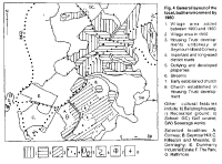
Fig. 4 General layout of the local,
built environment by 1960
- Village area added between 1900
and 1960
- Village area in 1900
- Housing Trust developments
underway at SeymourHill and Conway
- Important and long-used district
roads
- Outlying and developed
properties
- Streams
- Early established church
- Church established in Housing
Trust development
-
Other cultural
features include: b) Ballybog
housing; r) Recreation ground; s)
School; GC) Golf course; SW)
Sewerage works.
-
Selected
localities: A. Conway; B. Seymour
Hill; C. Killeaton and Mosside; D.
Derriaghy; E. Dunmurry Industrial
Estate; F. The Park; G. Rathmore.
By the spring of 1956 233 houses were
completed at Suffolk whereas only 13 dwellings had been
provided at Seymour Hill (Dunmurry). In March 1959,
however, 494 dwellings had been completed at Seymour
Hill (and the housing target there had been raised to
790 dwellings). Five shops had been opened there, three
churches built and arrangements agreed to provide for
the needs of senior citizens. Land adjacent to the
Seymour Hill development, on the former Conway estate,
had also been acquired by the Trust for building another
850 houses'.
Shortly after 1960 the first
multi-storied blocks of flats were completed at Seymour
Hill and Conway by the Trust, which had now turned its
attention to open fields on the west side of the
village.
The local scene
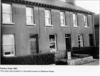
In 1900 buildings in Dunmurry village were loosely
grouped together on the north side of the railway track
close to a textile mill, corn mill, church and school. A
short distance away lay a small cluster of buildings
associated with Dunmurry House and a linear strip of
housing on what was to become Ashley Park. South of the
railway short ribbons of buildings lined the north side
of the main Lisburn to Belfast road, as well as on the
south side of Upper Dunmurry Lane. Both Seymour Hill and
Glenburn Houses were the foci of separate building
clusters as was the Barbour mill with its workers
cottages. Brick was and has remained the chief building
material in domestic property although stone has been
employed in some formal structures and large country
houses.
Early in the 20th century
Milfort Weaving Company was established on the east side
of Glenburn Road and stimulated local employment and
house building nearby. Labourers' cottages appeared at
Ballybog in 191010 and
a start was made with housing on Ulster Avenue, Church
Avenue and The Green at about this time. After World War
I the gently sloped ground at The Green, Ashley Park and
Milfort Avenue proved attractive to builders, as did
vacant land on the south side of the main street (i.e.
Kingsway). On the ground it can be seen that
comparatively short blocks of houses were first built
alongside roads of increasing importance or near the
railway station and the textile factories. Gaps between
buildings at these sites were soon to be infilled as the
population increased. Associated with this phase of
development came the parlour shop or parlour office and
hutted work places. Soon they were to be accompanied by
ground floor conversions of some appropriately placed
houses to provide house based shops – many of which are
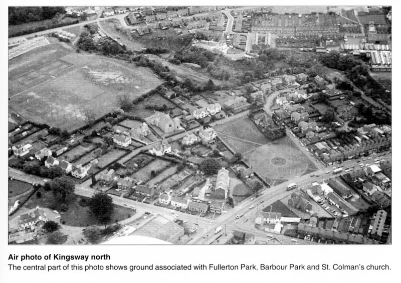
still in use today. (See Figure 5.)
After 1928, however, the scale, types
and continuity of housing development were to change in
the village11. Between
1928 and 1938, for example, permission to build houses
at what became Sunnymede Park and Sunnyhill Park
exceeded a total of 130. At The Green and Beechlawn Park
permission was given to build 80 houses of a different
quality. Meanwhile the Upper Dunmurry Lane, Glenburn
Road and Milfort Avenue were each subject to c 20
applications for new housing of diverse appearance. New
shops appeared on Kingsway12
and several more dwellings were to be added to Malone
Gardens, Church Avenue and Milfort Avenue.
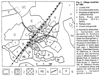
Fig. 5 Village localities by 1960
- Locality limit
- Converted textile works
- Kingsway shopping and commercial
strip
- Rafts, Floats and Dinghies (R.F.D.)
factory
- Railway track
- Church and grounds
A. Thornhill; B.
Ashley Park; C. Sunnymede and Sunnyhill;
D. Dunmurry House and grounds; E. The
Green and Grange Park; F. Former textile
complex; G. Housing of mixed dates; H.
Properties of mixed
ages and uses; J. Beechlawn Park; L.
Beechlawn House; M. Rathmore; N. Church
Avenue and Dunmurry Lane; O. Milton
Avenue; P. Beattie Park; Q. Glenburn
Road; R. Ulster Avenue; T. Park House;
U. Seymour Hill; W. Glenburn House; Y.
Contractors offices and depots; GC. Golf
club and course; r. recreation ground;
s. School.
During the years between 1946 and 1956 a considerable
effort was made to provide housing in Beattie Parkx,
Mosside and Killeaton13 where initial
applications were for 90, 88 and 70 dwellings
respectively – properly serviced and planned layouts.
Modest rates of building continued at Beechlawn Park,
Upper Dunmurry Lane and The Green but the new and rapid
housing development at Grange Park was noteworthy.
On the north side of the village
house builders turned their attention to Blacks Road,
Larkfield and Wm. Alexander Park. On the southern
fringes the abandoned Army Nissen huts at Ballybog and
Glenburn House attracted attention. Those at the former
site were converted to temporary three or two bedroom
units in 1947. As this accommodation was prone to
problems of dampness and poor sanitation it was soon
abandoned. In 1953, however, this site was zoned for a
new secondary school, a sound decision as the successful
Dunmurry High School has proved.
x 56 houses had been
completed and another 14 were almost ready for use
at Beattie Park by the spring of 1952.
As previously indicated 1953 was
highly significant for the appearance of the N.I.
Housing Trust in Seymour Hill, on former demesne land.
The Trust provided four-storied maisonettes,
three-storied flats and two-storied semi-detached or
terraced housing for new residents. Seymour House and
associated buildings were converted to flatted
accommodation. Antrim County Council soon became
involved here with the construction of Seymour House to
cater for 60 old persons while the Trust also provided
32 small bungalows nearby for more retired persons.
Clearly the pattern and the scale of
house building in and about Dunmurry have changed
considerably since 1900. Simple accretion was first
replaced by planned neighbourhoods of limited size which
then gave way to planned estates of hamlet or village
sized proportions14.
Obviously all these building developments have
influenced rateable values in the district.
Firstly, they indicate how new
developments can influence assessments of ground
valuations. Secondly, they demonstrate how the value of
money has changed over the years. Thirdly, they indicate
how administrative changes can also influence
valuations. In 1937, for example, rateable valuations
were based upon the land, buildings and public utilities
available. But because of an appropriate Act in 1929
agricultural land was derated while industrial and
transport facilities were partly derated. Financial
shortfalls thus created were to be met from Government
sources. Again part of Lisburn Rural District was
transferred to Lisburn Urban District in 1955 while
ground of Belfast Rural District was transferred to
Lisburn Rural District in 1958.
Turning to the local scene it is
noteworthy that the rateable valuation of Dunmurry
townland changed from £6183 in 1901 to £41,549 in 1961
while the population rose from 1426 to 4607. Between
1926 and 1937 the valuation increased by almost 50%,
between 1937 and 1951 it then increased by just over 50%
whereas between 1951 and 1961 it rose by 60%. And as
might be expected the rateable valuations at Killeaton
and Kilmakee began to rise significantly once
considerable growths of population and property occurred
in the 1950-60 decade15.
Agricultural land use
As in other parts of the province agricultural land
use in the local district has also changed considerably
since 190016. World War
I encouraged the small farmers of the province because
of increased demands for foodstuffs, flax and linen.
After 1922 changed political status, market conditions
and growing competition from elsewhere adversely
affected employment in Belfast shipyards, linen mills
and farming – even though wages were relatively low and
production methods had slowly improved. Following the
Agricultural Act (N.I.) of 1933 increasing numbers of
cattle and pigs together with rising prices for potatoes
and eggs soon reflected improvements in sections of the
farming industry17.
Conditions in World War II again
stimulated farming activities so that the ploughed area
increased, as did the output of foodstuff and flax. In
the aftermath of this war Government showed greater
urgency to promote stability and acceptable returns for
farming, especially in livestock, potato, egg and cereal
production. Financial aid was made available to milk,
wheat and fat cattle producers to foster progress.
In the Lagan valley the urban growth
of Belfast between 1851 and 1901 was considerable, i.e.
from 80,000 to 350,000 residents, but by 1951 this
city's population had reached 443,000. Nearby farmland
that was formerly given to cereals, potatoes and green
crops declined whereas the grassland area, milk
production and numbers of dairy cattle, store cattle and
pigs had increased by 193918.
Dunmurry district lay in a zone of transition by this
date, between the dominant grassland zone downvalley to
the increasing amount of arable land upvalley. Mixed
farming activities with the growing of oats, potatoes
and root crops alongside the keeping of livestock still
remained noteworthy towards Lisburn and beyond. Another
indication of change locally was the closure of the corn
and flour mill in Dunmurry village by this time.
At the outbreak of World War II local
farm holdings rarely exceeded 40 acres and not
infrequently they were less than 20 acres. As in
adjacent townlands these farms were reliant upon family
labour. The traditional habit of letting small areas for
periods of less than one year was still maintained. This
practice of conacre originally involved short term
rentings for a single crop but a diversity of useage had
gradually occurred.
Sheet 7 of the 1" Land Utilisation
Series of maps, published by the Ordnance Survey,
indicates ground conditions in 1938. This sheet shows
that much of the land below 600 ft in Dunmurry district
was dominated by pasture. Limited areas of trees lined,
the Glen and Derriaghy burns or lay scattered on small
estates. Hills to the Northwest were given over to rough
grazings and were occasionally scarred by quarry sites.
Gardens and allotments were noticeable in or near
Dunmurry village.
Vertical Air Photographs taken by the
R.A.F. in 195819 are
noteworthy for three sets of features in the Dunmurry
district. Firstly, the grasslands used for grazing, hay
and recreation were important in Dunmurry, Killeaton and
Old Forge townlands. Secondly, there had been an
extensive spread of new housing upon the former
grassland of west Finaghy and southern Suffolk. Thirdly,
there was a marked contrast between the results of
ambitious housing developments in Kilmakee (at Seymour
Hill) and the more localized house building on the
northwest, north and east fringes of Dunmurry village.
Thankfully some attempts were to be
made early in the 1960-70 decade to protect the natural
environment near to the Lagan, Glen and Derriaghy burns
and to scale down some of the building proposals for the
use of open ground elsewhere in this district.
People and Place
Bibliography
-
Common R. The Glen burn at
Dunmurry 1974-75. Geography Dept. Research
Papers (1) Queens University Belfast 1977.
- Common R. Some Observations on Dunmurry's
Past, Regency Press, Belfast 1999.
- Reports of the Agricultural
Enquiry Committee Cmd. 249. H.M.S.O. Belfast
1947.
- LA47/2FA/9 in P.R.O.N.I.
- LA47/2FA/12 in P.R.O.N.I.
- LA47/2FA/l3 in P.R.O.N.I.
- LA47/12C/I P.R.O.N.I. Also HLG6/3/12
P.R.O.N.I.
- Brett C.E.B. Housing a divided community.
Inst. of Public Administration Dublin 1986.
- N. Ireland Housing Trust Annual Reports
1954-62, also Common R. (edit) Northern
Ireland from the Air. Q.U.B. 1964 p 94.
- LA47/2FA/4 in P.R.O.N.I.
- LA47/2FA/10 and I 1 in P.R.O.N.I.
- LA47/2FA/12 and 13 in P.R.O.N.I.
- LA47/2FA/20, 21, 24 and 26 in P.R.O.N.I.
- Common R. Irish Troubles. Town and
Country Planning 1970 p 91.
- Population and valuation figures were
obtained from Census data for 1901, 1911, 1926,
1937. 1951 and 1961.
- Symons L. (edit) Land Use in Northern
Ireland, University of London Press.
- Ulster Yearbook 1935. H.M.S.O. Belfast.
- Hill D.A. The Land of Ulster. The
Belfast Region. H.M.S.O. Belfast 1948.
- R.A.F. Sortie 543/343 Prints 016-019.
P.R.O.N.I.
Water supply, sewerage and
sanitation
As a result of the 1884 Act parts of the local townlands
became involved with pipelines and reservoirs at
Stoneyford and Lagmore to supply water to Belfast. A
subsequent Act in 1889 resulted in the addition of
Leathamstown reservoir and the establishment of the
Belfast Water Commissioners (B.W.C.) Six years later
B.W.C. sought to widen their supply area with extensions
that included Finaghy and Dunmurry. And so by 1899 part
of Dunmurry townland had been officially incorporated
into Belfast's water responsibilities. At that time the
boundary line of this expansion was provided by the
Upper Malone Road to the east, parts of Dunmurry Lane
and Glenburn Road westwards as far as the present day
Ulster Avenue. This line then swung to the nearby course
of the Derriaghy burn. This stream was next followed
towards Twinbrook farm before the line turned eastwards
to cross the Glen burn and then Blacks Road, near
Arlington House. Further incorporation of the village
area was soon to follow.
Previously both a local Dispensary
Committee (established in 1852) and then L.R.D. Council
were actively concerned with matters of water supplies.
In the late 19th century, for example. the
Dispensary Committee expressed concerns over the
occurrences of cholera and diarrhoea, as well as the
needs for safe water supplies and vaccinations to
improve health standards. For some years it was an
obligation of the Dispensary's medical officer that he
should also act as this committee's sanitary officer.
Once Rural District Councils had been established.
however, both supply and sanitary obligations became
their responsibilities. Nevertheless successive medical
officers all engaged in long campaigns1
to lessen the risk of water borne diseases in this
district. They were also actively concerned about
pollution risks in the Derriaghy and Glen burns from
mill sources and refuse dumping by members of the
public. The lack of an effective means to collect and
dispose of domestic refuse was yet another problem that
engaged their attention.
By 1903 the whole village had been
included in the B.W.C. supply area2,
hut the prospects for a piped supply to Lambeg and
Derriaghy were deferred. At this time large houses in
their associated estates about Dunmurry usually
possessed their own assured supply of ground water. In
the village itself pumps and wells were located
alongside the main roads but not too distant from
existing properties on Glenburn Road, Upper Dunmurry
Lane and the west side of Kingsway. (By 1895 they
already totalled 20.) Although ground water usually
offered a safe supply of water the cost of sinking wells
and fitting pumps was not cheap. x Not
surprisingly, therefore, by 1910 cash allowances came to
be offered for this work in Dunmurry Dispensary
District. At this time preferences were for wells and
pumps in rural localities but for piped water in the
village. Expectations there had multiplied for supplies
of drinkable water, water for house toilets, water for
planned sewerage facilities and water for industrial
purposes3.
x Sinking a well, early in the
20th century, cost from 22½p or 4/6d per foot in
sandy material to 75p 01 15/- per foot in clay
deposits, down to 31 m or 100 ft depth.
Between 1910 and 1920 resources were
committed to supply parts of Dunmurry district with
piped water for domestic use and sewerage disposal,
along with a sewerage treatment plant beside the R.
Lagan. Disquiet was publicly expressed by village
residents in 1925 about disease stemming from insanitary
conditions in some quarters and the lack of proper
disposal for domestic refuse4.
Two years later both a Ratepayers Committee and the
Dispensary Committee reinforced this disquiet with
strong views on these particular problems. Not until
1928, however, did the L.R.D. Council agree to provide
the proper removal of household refuse.
The 1930-40 decade saw both inertia
and change over water utilities. By 1933 there were at
least 14 houses in the village still without water
closets and after 21 years of service the local sewerage
treatment works needed repairs. On the other hand the
rising demand for housing in the mid 1930s brought with
it a change in building habits, in that basic domestic
water facilities were now provided before occupation.
Nevertheless in May 19386
there were 25 houses and 6 house based shops in the
village which possessed rear yards with no exits, so
that refuse had to be carried through the buildings for
disposal. (And some still remain today.) In the meantime
the collection and disposal of refuse by L.R.D. Council,
with the payment of local contractors, had been subject
to a series of problems. A series of local sites for
dumping refuse were used first, but for short spells
only. These were then replaced by other sites with
longer expectancies first at Lambeg in 1950 and then at
Castlerobin in 1956.
Sewerage problems continued to be
troublesome in the 1940-50 decade as demands for new and
better services developed in parts of Lambeg, Derriaghy
and Dunmurry townlands. In both 1948 and 1949 the
Ministry of Health offered financial assistance for
suitable schemes in these areas. The capacity of
sewerage treatment works at Dunmurry already had been
overstretched by 1948 when raw sewerage had been
discharged into the R. Lagan.
Work began to improve local sewerage
facilities in 19518 and
for a new sewerage treatment plant at Dunmurry in 1954.
Four years later this plant was completed and it was
designed to serve 32,000 persons living in the districts
of Dunmurry, Lambeg and Derriaghy. In spite of the Water
Supplies and Sewerage Act (N.I.) of 1945 and decisions
made to improve water services, shortcomings still
persisted between 1950 and 1960 at scattered domestic
sites through these areas. This is spite of the fact
that since 1945 Joint Boards, acceptable to Local
Authorities, had also been promoted to provide adequate
sewerage and water supply facilities in rural areas9.
Gas
In 1823 a gas supply was first made available to
Belfast, with the resident population of c 37,000. Two
years later an agreement between Belfast Gas Light Co.
and Belfast Police Committee led the way to the
provision of street lighting in the city. As the result
of a Gas Act in 1874 growth and development soon led to
the transfer of gas undertakings to Belfast Corporation.
Over the next 75 years the volume of gas produced, the
area of its distribution and the number of gas consumers
were all to grow significantly10.
In 1856 Lisburn possessed its own gas
supply where the growth of demand by 1881 had resulted
in there being two competing gas companies. When Lisburn
Urban District Council purchased these undertakings in
1910 it sought to satisfy the existing demands of c 1000
customers11. The 1909
enactment that allowed this purchase to take place
stimulated L.R.D. Council members to discuss the
possibility of a piped gas supply to their residents,
but without reaching any firm decisions. In due course,
therefore, the felt need for gas to meet Dunmurry's
domestic needs and possible commercial outlets was to be
met from Belfast sources, by way of Finaghy.
Gas produced in Belfast served c
94,000 consumers in 192912
and by this time Whitehouse, Finaghy, Dunmurry and
Cregagh had been added to the Belfast supply system.
Although the volume of gas produced in Belfast reached
5,065 million cubic feet in 1959, the demand for a gas
supply was now about to decline emphatically because of
competition from sales of oil and electricity. Because
of production and distribution problems Lisburn Gas
Committee had already asked, Belfast Corporation about
the provision of bulk supplies for its needs. Not until
1967, however, did Lisburn also become reliant upon gas
supplies from Belfast.
Thus in spite of technical
innovations after 1960 the gas industry in the province
gradually declined in its importance. Only at the end of
the 20th century was interest in the use of gas
rekindled in the Dunmurry area through the availability
and supply of natural gas provided by the Phoenix
Company.
Electricity
Gribben13 has
already noted the local installation of water turbines
in three bleaching and one textile printing works as
well as in one lime works and one electric lighting
generating plant during the first quarter of the 20th
century. And it was to be the site of a former beetling
mill at Dunmurry that was chosen for the short lived
Dunmurry Electric and Power Company14.
(This author also referred to the earlier use of water
power for the corn mill at Dunmurry and the spade mill
at Derriaghy, both which were established c 1812.)
Dunmurry Electric and Power Company
was officially registered in June 1922 with the
intention of supplying local and public properties.
Local citizens were quick to press for additional
services. Although most of the shares for this company
had been purchased by local residents in November 192315,
they had next been acquired by Lisburn Electric Supply
Company ten years later. This Lisburn company had
already settled for an electric supply from Belfast and
had also agreed to take over the Dunmurry company before
closing down its own plant.
Meanwhile, in 1925, a survey was made
on the likely demands for an electricity supply in the
Lagan valley16. It was
found that Kilwee, Milfort and Crawford's textile plants
in the Dunmurry area were reliant upon steam power, but
the owners of Milfort and Crawford's were sympathetic to
the use of an assured electricity supply. It was also
ascertained that Kilwee employed 60 persons while
Charley's (at Seymour Hill) had 50 employees and the
Barbour factories in Dunmurry and Hilden involved 1,500
workers.
Lisburn Council members were at first
undecided about the use of public funds in the
generation and distribution of electricity since it
already possessed a thriving gas company. After two
years debate these matters had been resolved and by
December 1928 the main transmission line between Belfast
and Lisburn had been erected, tested and become
operational, thereby ensuring Dunmurry's supply.
Early in the 1930-40 decade there was
a flurry of street light installation first on Kingsway
and then on Blacks Road. With the enactment of the
Electricity Supply Bill in March 1931 came restructuring
of the provincial electricity service. Consequently the
next street lighting programme for Dunmurry and Finaghy
affected side roads after 1950 under the auspices of the
Electricity Board of N.I. Meantime between 1950 and 1960
the sale of electricity in the province was doubled,
with the domestic market accounting for one third of
this business.
Public transportation
The early provision in 1839 of railway passenger
services between Belfast and Lisburn, with an
intermediate stop at Dunmurry has already been mentioned
elsewhere17. Passenger
ticket sales and the frequency of trains before the end
of the 19th century were indicative that
local people soon realized the benefits offered by the
train services.
Early in the 20th century
concessionary fares offered at reduced rates and other
innovations were introduced to attract more passengers
to and from Dunmurry. The Lisburn Standard
newspaper listed c 50 weekday trains each way between
Belfast and Lisburn in 190818,
with 31 of them stopping in Dunmurry en route, both to
Belfast and to Lisburn. Even by 1915 there were still c
40 weekday trains available. In 1916, however, an Order
in Council placed railways under Government control and
it was not until 1921 that tracks were handed back to
the Great Northern Railway. Rehabilitation work on the
railways began in 1923 but by then the competition from
road transportation had become significant. Indeed, this
new form of transport obliged G.N.R. to provide its own
ancillary services for a short period in 1927.
Overall G.N.R. passenger totals
declined between 1922 and 1938 but then almost doubled
by 1944 before declining once more. Merchandise carried
by rail also declined between 1922 and 1934. During the
Second World War years, however, the tonnage carried by
rail was twice the amount carried in 1934.
Bradshaw's Railway Guide for July
193819 indicates that
the number of weekday trains between Lisburn and Belfast
stopping at Dunmurry was still noteworthy, i.e. 43
inbound to and 52 outbound from Belfast, with 10
stopping trains each way on Sundays.
With the return of peace, after World
War II, came the 1948 Transport Act (N.I.) and then by
1958 the reestablishment of 50 weekday trains each way
between Belfast and Lisburn. When the Benson Report
appeared in 196320
there seemed to be very little difference in train and
bus journey times between Belfast and Lisburn, but
frequency of services and convenience of access favoured
the bus services.
Increased personal mobility since
then, through the use of cars, is obviously reflected in
the reduced number of passenger trains stopping at
Dunmurry Halt (rather than station) in August 2002. On
weekdays in this month only 29 trains going each way
stopped between Belfast and Lisburn (including those
coming from or going to Portadown). On Sundays there
were only nine trains going each way which called at
Dunmurry.
In spite of changes over the years
there have always been more passenger services in the
afternoon and evening periods. There is also little
doubt that passenger services have remained significant
to the many commuters who travelled to and from Belfast
during the working week.
Late 18th century maps and
diagrams indicate that the two main roads between
Belfast and Lisburn followed either a hill foot route by
way of Suffolk, Derriaghy and Lambeg or used the Malone
ridge towards Drumbeg before crossing the R. Lagan and
then turning west through Lambeg. A convenient cross
valley linkage to these roads passed through Dunmurry
and in 1780 this route branched just east of this
settlement21. A
southern portion crossed the Glen burn and then the
Derriaghy burn (near present day McMaster's bridge) to
join a road leading to Lisburn. The northern portion
passed through Dunmurry and headed for Suffolk, but it
was linked to the southern portion by what are now
called Glebe Road and part of the present Glenburn Road.
Because of wet ground conditions it
was not until the early 19th century that a
satisfactory road became available between Balmoral
(Belfast), Finaghy and Dunmurry, connecting with a road
to Lisburn by way of Lambeg. Management of the main
roads in the lower Lagan valley was short lived,
however, following the terms of the 1837 Turnpike Act
for responsibility for roads and bridges soon passed to
County Councils in 1898. At the beginning of the 20th
century, therefore, Dunmurry townland and village did
possess basic linkages with Belfast and Lisburn by rail,
road and water, i.e. the Lagan river and canal. The
Local Government (Roads) Act of 1923 finally introduced
a new system for the classification and designation of
responsibilities over roads in the province.
By 1909 the average annual
maintenance costs for 385 km or 232 miles of road in
L.R.D. Council's area amounted to £8670, involving a
labour force equivalent to 67 men. Dunmurry's share was
an average annual amount of £47.59 or £47-11-8. This
year was also noteworthy for L.R.D. Council's decisions
to use direct labour on road maintenance work and to put
in hand work on the main road through Dunmurry in
succeeding years. (Local unemployment levels promoting
winter relief work on the reconstruction and resurfacing
of roads came later.)
After World War I public
dissatisfaction in the village was soon expressed about
the dangerous railway crossing to Ashley Park23,
the speed of motor vehicles through the village, the
condition of roads and footpaths in seven different
locations (Kingsway, William Street, Hill Street,
Station View, Milfort Avenue, Glenburn Road and Upper
Dunmurry Lane). Piecemeal improvements followed these
complaints about roads and footpaths. Not until the end
of 1959, however, was the problem of the dangerous
railway crossing settled. Possible solutions to reduce
accidents there began in 1912 and included bridging or
tunnelling. Eventually Sunnymede Park was extended to
join Ashley Park, providing for wheeled vehicles, but a
pedestrian crossing only was established over the
railway track.
Bus and truck numbers between Belfast
and Lisburn had clearly demonstrated the flexibility of
their services by the middle of the 1920-30 decade, with
reasonable prices on both main and minor district roads.
A bus journey between Belfast and Lisburn, for example,
involved a 30 minute journey and a single fare was
calculated at the rate of 1d per mile24.
The increasing use of these roads also demonstrated the
usefulness of direct labour to improve and maintain
them.
Rationalisation to reduce the rising
competition between rival bus owners began seriously in
1927, with the merging of the Spenses, Classic and
Violet companies of Lisburn into the Belfast Omnibus
Company. Almost all B.O.C. buses went through Dunmurry
on services between Belfast and Lisburn, save for the
few that travelled either by way of Suffolk or Hillhall.
This bus company provided both passenger and parcel
services along these routes. Middle distance services
between Belfast and Armagh as well as those between
Belfast and Newry were also absorbed by this same
company. And not to be outdone the Great Northern
Railway also instituted a bus service between Belfast
and Lisburn between 1929 and 1935. Long distance buses,
belonging to Catherwoods, next appeared in Dunmurry on
weekdays as the result of their introduction of a
Belfast to Dublin service.
Before long both the local and
provincial scene was to be drastically affected again
with the establishment of the N.I. Road Transport Board,
as the result of the Road and Rail Traffic Act (N.I.) of
1935. This new Board sought to coordinate road and rail
services across the province and it took over 687 buses
and 1600 freight lorries in October 1935.
Subsequent events next produced the
Transport Act (N.I.) of 1948 and the establishment of
the Ulster Transport Authority. Significant to
Dunmurry's labour force was an early decision by the
N.I.R.T. Board to establish a production unit in the
village. This unit constructed standardized 34 seater,
single deck bus bodies and occasional double decked bus
bodies for several years. Once vacated, early in the
1950-60 decade, this site next provided a nucleus for
the R.F.D. (Rafts, Floats and Dinghies) factory, an
enterprise which has successfully thrived there into the
21st century.
Within the village itself the
continued rise of through traffic again produced public
disquiet in 1950, exacerbating a long-standing problem
that has still to be solved. Council consultations and
agreement within the Ministry of Commerce between 1957
and 1960 over a fast South Approach Road to and from
Belfast presumably resulted in the M1 motorway.
Meanwhile both bus and train services have had to cope
with rising competition from privately owned vehicles.
No doubt the rising costs of weekly bus and train fares
from Dunmurry either to Belfast or Lisburn have also
affected personal choices since 1960x.
Public Utilities Bibliography
- LA47/2FA/2 See Dr. Gaussen's concerns in
P.R.O.N.I.
- WATI/3H/1/3 Belfast Water Acts 1840-1920 in
P.R.O.N.I.
- Loudan J. In search of water (A
history of Belfast water supply). Mullan.
Belfast 1940
- LA47/2FA/9 and 10 in P.R.O.N.I.
- Lisburn Herald Aug. 27th
1929 carried notice about land for refuse
dumping.
- LA47/2FA/15 in P.R.O.N.I.
- HLG6/3/3 Comments on need to improve water
and sewerage facilities in P.R.O.N.I.
- LA47/2FA/24 in P.R.O.N.I.
- Flannery M. Sanitation, Conservation and
Recreation. Inst. Public Administration
Dublin 1976.
- Cameron T.R. N.I. Gas Industry
C. Inst. of Building Services. Inst. of Fuel
N.I. Belfast 1979. Also O'Sullivan C.J. The
Gas Makers. O'Brien Press. Dublin 1987.
- Lisburn Standard Dec. 4th
1931 Lisburn Gas Company.
- LA7/19/19/1G/1 Belfast Gas in P.R.O.N.I.
- Gribben H.D. The history of water power
in Ulster. David & Charles. Newton Abbot
1969.
- COM40/2/32 Dunmurry Electric and Power Co.
in P.R.O.N.I.
- LA47/2FA/8 in P.R.O.N.I.
- COM58/1/27 in P.R.O.N.I. See also Belfast
Newsletter July 10th 1925 on
Electricity Supply.
- See for example McCutcheon W.A. The
Industrial Archaeology of N. Ireland.
H.M.S.O. Belfast 1980.
- Lisburn Standard Jan. 415
1908 provides a railway timetable.
- David & Charles reprint from Bradshaw's
July 1938 timetable S.E.E.L.B. Ballynahinch.
- N.1. Railways Report. Benson H. Cmd
458 H.M.S.O. Belfast 1963 in P.R.O.N.I.
- Lendrick's 1780 map showing Lagan valley
roads at Linenhall Library, Belfast
- In both 1957 and 1958 the Lisburn Herald
drew attention to the poor state of the
Lagan Canal. In March 1958 the Ministry of
Commerce abandoned it from Stranmillis to
Sprucefield.
- LA47/2FA/7 in P.R.O.N.I.
- Kennedy M. and McNeill D. Early bus
services in Ulster. Inst. of Irish Studies
Q.U.B. 1997.
x Lisburn Herald in June 1954
noted that a weekly bus ticket between Lisburn and
Dunmurry rose from 29p to 39p or 5/10d to 7/10d while
the equivalent train ticket rose from 24p to 29p or
4/10d to 5/7d.
|