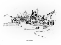
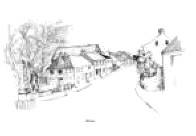
The Borough - Past to Present circa 1975 +
Click on town or village to read about village or town
Introduction
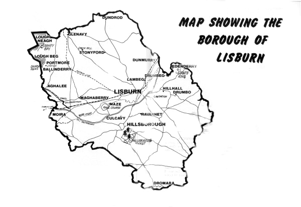
The Borough of Lisburn is a much enlarged area since October
1973 when local government was re-organised. The present Borough includes
the old Borough of Lisburn and a number of villages, including Moira,
Dromara, Glenavy and Dunmurry (see map, centre pages). The Borough has a
population of approximately 81,000 and is one of the fastest growing areas
in Northern Ireland.
The old Lisburn Borough was an unincorporated Borough until 1885 and an
Urban District from 1899 until 1964,when a Royal Charter of Incorporation
was granted elevating Lisburn to Borough Status. On the 30th September 1973,
the Borough of Lisburn as then constituted ceased to exist and a new Council
was established, the members having been elected in May 1973, in accordance
with the Provisions of the Local Government Act (Northern Ireland) 1972 to
administer the new enlarged Borough of Lisburn.
The area is a region of contrasts from the up-and-down drumlin country of
Down and the hills around Dromara to the calm of the Lough Neagh shore at
Sandy Bay with its potential for fishing, boating and bathing to the hustle
and bustle of the urban area of the Lagan Valley. Beautiful views across
Lough Neagh to the Sperrins can be seen from the countryside above Dundrod (Bohill)
and Glenavy's Crew Hill, a place where the ancient kings of Eastern Ulster
were crowned.
As a residential area Lisburn Borough is most conveniently situated being on
the outskirts of Belfast and yet right in the middle of the Lagan Valley
straddling the main routes North and South and to the centre of the
province. The area is also adjacent to Aldergrove Airport, the main airport
in Northern Ireland.
GENERAL HISTORICAL BACKGROUND
 The
land of Ulster, in common with other regions of the British Isles, has been
occupied by man for many thousands of years, and the present landscape bears
the stamp of that long occupancy. The natural scene of prehistoric times has
been profoundly transformed, for the cultivated countryside and bare hills
we see to-day have replaced a forested lake strewn land. From the time when,
over forty centuries ago, simple farming skills began to be practised in
Ireland, there has been continuous interaction between human groups and
their environment, and not all the changes flowing from man's activities
have been to his ultimate benefit. The
land of Ulster, in common with other regions of the British Isles, has been
occupied by man for many thousands of years, and the present landscape bears
the stamp of that long occupancy. The natural scene of prehistoric times has
been profoundly transformed, for the cultivated countryside and bare hills
we see to-day have replaced a forested lake strewn land. From the time when,
over forty centuries ago, simple farming skills began to be practised in
Ireland, there has been continuous interaction between human groups and
their environment, and not all the changes flowing from man's activities
have been to his ultimate benefit.
Archaeology and legend tell of a succession of invasions during the last
millennium B.C. which brought a Celtic culture and a Celtic tongue to the
island. The Celticising process was not completed until early Christian
times, but ultimately a Celtic hierarchy was established in all parts of the
country. The gradual adoption of Iron cutting tools from about 300 B.C.
onwards allowed new adjustments to be made between man and his environment.
Cattle became the chief source of wealth, and the need to protect them from
raiders
including wolves helps to explain the earth or stone-ringed farmsteads (raths
and cashels) which survive in their thousands among the cultivated fields of
to-day. These constructions belonged to substantial farmers who claimed the
rights to freedom and who were descended, it is thought, from one branch or
another of the conquering Celts.
The struggle between Ulster and Elizabethan England, which ended with the
Flight of the Earls in 1607, was a clash between two civilisations. The
ancient culture of the Gael, with the clan providing the social base and
farming providing the economic base was finally broken by superior force, by
wholesale devastation, by the destruction of forests and the building of
roads and fortresses to isolate and divide the various districts of the
province. For all its archaisms, however, the Gaelic way of life, with its
aristocratic traditions, its ancient laws and oral literature was far
removed from the barbaric nomandism which contemporary English writers, and
following them many later historians, have read into it.
There is a further aspect of the Ulster heritage which stems indirectly from
the pastoral way of life of earlier times.
The Plantations of the early 17th century were necessarily concerned with
the establishment of market towns, for the Gaelic order had not needed urban
centres, and in 1600 AD the only settlements with any pretensions to urban
status were the small post towns such as Carrickfergus and Ardglass which
had been founded by the Angle-Normans. The new towns, although they remained
small, acted as centres of administration and of urban influences as well as
being market towns, enjoying regular fairs which took the place of the
native gatherings which had been held regularly on some lonely hallowed fair
green. The new towns helped the Ulster plantation to succeed and become the
chief instruments through which a consciousness of the Angle-Scottish
Protestant tradition was fostered.
The period of independence (1782-18001 was a time of prosperity, bath for
landlords and for the rising urban populations. There was much expenditure
on public works and roads. Market towns expanded and were in many cases
re-planned and some new towns, typically with wide main streets, were
established. It will generally be found that the oldest surviving houses and
inns in the Ulster towns date from this period; the extreme rarity of any
pre-Georgian secular buildings must strike the English visitor. Many country
mansions and farm houses were built or reconstructed either just before or
soon after 1800. The town of Lisburn and the villages of the Borough can be
looked at with this background.

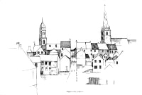
The Town of Lisburn
Lisburn was originally laid out by Sir Fulke Conway, from Wiles, in 1609,
when it was called Lisnagarvey. Its revival after the great fire of 1707 was
due chiefly to the Huguenots, and names of French origin are still fairly
common in the district. It was a Lisburn linen. merchant, Henry Munro, who
led the United Irish insurgents in County Down. In 1798 he was hanged in
Market Square.
 Lisburn is a busy industrial town on the River Lagan (which forms the S.
boundary of County Antrim) 13 km. south of Belfast at the intersection of
the M1 motorway with other main roads. The town, including the cathedral and
the former castle, was almost completely destroyed by an accidental fire in
1707, so that modern Lisburn has few ancient structures. Lisburn is a busy industrial town on the River Lagan (which forms the S.
boundary of County Antrim) 13 km. south of Belfast at the intersection of
the M1 motorway with other main roads. The town, including the cathedral and
the former castle, was almost completely destroyed by an accidental fire in
1707, so that modern Lisburn has few ancient structures.
There is an open-air market at Smithfield Square on Tuesday mornings, a golf
course at Blaris on the south outskirts, a modern swimming pool at the
centre of the town and good coarse fishing in the River Lagan, lakes and
streams.
The centre of the town suffers from planning blight and
substantial redevelopment is scheduled. The first section of a through-pass
road is complete and the second phase now under construction will link
Bridge Street with Seymour Street.
Perhaps the most interesting building, in the town, is Christ Church (C. of
I.) almost concealed behind houses to the east of the Market Square. It is a
characteristic example of 'Planters' Gothic, built originally in 1623 and
reconstructed in 1708. The slim octagonal spire was added in 1804. The
original church was given cathedral status by King Charles II in 1662, when
he raised Rev. Jeremy Taylor to be Bishop of Down and Connor as a reward for
his services in the Royalist cause. Bishop Taylor died in Lisburn in 1667
and was buried in Dromore Cathedral.
Conspicuous in the middle of the Market Square is a vigorous bronze statue
of Gen. Nicholson (by F. W. Pomeroy, R. A.) with a sword in one hand and a
pistol in the other as he led the attack on Delhi, where he was killed at
the age of 35. Nicholson, born in Dublin, was brought up in Lisburn. Awe of
him in India was so great that a sect came into being that thought him a
god, 'Nikkul Weyn'.
The Assembly Rooms, in the square, have a domed clock and a handsome
interior. A plaque in an external wall was rescued from the first house
rebuilt after the great fire and dated 1708.
Castle Gardens, on a slope between the cathedral and the river, retain part
of the gateway of the former castle.
Wallace Park is a well-wooded 25 acre recreation area on the north side of
the town, with playing fields and an ornamental pond. It was presented to
Lisburn by Sir Richard Wallace, who lived in a house in Castle Street, now
forming part of the Technical College.
INDUSTRIAL DEVELOPMENT
Linen under the industrious Huguenots made Lisburn and just as the man-made
fibres have to a large extent taken over the role of linen, diversification
into other industries is now taking place to ensure continuing employment
for an expanding population. The Queen of textiles is, however, not dead,
and linen still continues to be processed as thread at Hilden, as are the
newer terylene and nylon products. Hilden has been producing linen thread,
twines and cordages since the war with Napoleon.
Another of the newer industries in Lisburn is cabinet-making. All modern
items of furniture are made both for the home market and for export. Many of
the more recently established manufacturing plants are working mainly for
export. Ball bearings are made almost entirely for export by a world-famous
firm. A subsidiary plant of a large American firm manufactures tyre valves
and accessories for sale in all corners of the Globe.
The economy of the old town of Lisburn was based on agriculture and to-day
many of the industries are still based on the oldest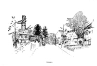 industry of all. Near
the town is one of the country's biggest plants for the manufacture of
animal feeding stuffs and in the Borough area there are two farm by-product
factories. Another factory exports eggs, and manufactures jam and cans all
sorts of farm produce and fruit for home and overseas consumption. Other
factories process poultry, hatch chickens and deal with all other types of
farm produce and vegetables. industry of all. Near
the town is one of the country's biggest plants for the manufacture of
animal feeding stuffs and in the Borough area there are two farm by-product
factories. Another factory exports eggs, and manufactures jam and cans all
sorts of farm produce and fruit for home and overseas consumption. Other
factories process poultry, hatch chickens and deal with all other types of
farm produce and vegetables.
Employment is also provided by plants which manufacture tape recorders, wire
ropes, clothing, pressure lamps and cookers and life saving equipment.
The development of industrial Lisburn still continues and many newer
industries are likely to move to the new industrial estates adjacent to the
town.
Progressive industrial development and an increasingly prosperous population
demand the services of a highly organised system of retail distribution.
Although many of the national multiple firms are represented 'in the area it
is a significant feature of the local commercial scene that the majority of
large business houses are family concerns with records of service to the
public going back for two or more generations.
Industrial development demands basic technical skills and technical
education has progressed to meet the needs of local industry. The textile,
engineering, building and furniture industries depend on the excellent
educational and training facilities provided in the area. The business
fraternity of the town find expression in the local industrial scene through
an active and progressive Chamber of Commerce.
Guide to further reading
Lisburn Cathedral and its Past Rectors, by Very Rev. W. P. Carmody.
The Lagan Valley (1800-1850), by E. E. R. Green.
A Concise History of Lisburn and Neighbourhood, published by T. H. Jordan,
Belfast, 1906.
AGHALEE
Aghalee is a pretty little village lying in the centre of the low lying
agricultural area that borders Lough Neagh. On the road from Lurgan
 toCrumlin it has grown somewhat in recent years and apart with its local
agricultural connection is a dormitory village for Lurgan and Lisburn. The
old Lagan Navigation Canal runs close to the village. Aghalee was the
birthplace of Sir John Lavery the famous portrait painter. toCrumlin it has grown somewhat in recent years and apart with its local
agricultural connection is a dormitory village for Lurgan and Lisburn. The
old Lagan Navigation Canal runs close to the village. Aghalee was the
birthplace of Sir John Lavery the famous portrait painter.
Approval has been given in Aghalee for the construction of approximately 50
houses and about six of these have been built. The Housing Executive has
permission to build 16 houses in the village.
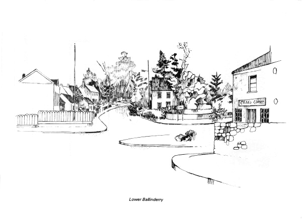
BALLINDERRY & LOUGH NEAGH
Ballinderry has been referred to as Ulster's Garden of Eden. At Portmore
there is the old ruin of the original site of the Church of St. Loo where
Jeremy Taylor delivered his gentle exhortations which have been immortalized
in his books "Holy Living" and "Holy Dying". The Middle Church was planned
by Jeremy Taylor but he did not live to see it consecrated. Inside it
breathes the spirit of the Spartan period of the middle 17th century with
its three-decked pulpit and high backed pews.
The Moravian Church was founded in 1750 by English born John Cennick he was
of Bohemian ancestry and a great preacher.
The whole Ballinderry area is most attractive and Lough Neagh adds to the
attractions of the area. The Rev. George Hill wrote of the scene many years
ago and of the thoughts of immigrants forced to leave the area:
|
Lough Neagh they used at close of day
Along thy silent strand,
To watch the
sun set far away,
O'er old Tir - Eoghan's land;
The fading light how like the
flight of hope from Inisfail
From holy hill so green and bright
From haunted
wood and vale.
And often were their children told Of Lough Neagh's silent
strand,
And of the sunset, spread like gold,
On old Tir - Eoghan's land. |
Apart from being the largest fresh water lake in the British Isles Lough
Neagh waters are supposed to have the power of petrifying wood. However,
more important is the fish produced in the Lough. Pollan, which could be
described as a fresh-water herring, is found in large numbers, as are other
members of coarse fish such as pike, roach and perch. Eels are also
plentiful.
The most important settlement, however, in the Ballinderry area was the area
around Portmore Lough (or Lough Beg) where Lord Conway erected a castle in
1664. The stables, which were 140 ft. long and 35 ft. broad and 40 ft. high,
afforded accommodation for two troops of horse. After the death of Conway
Portmore was neglected, the castle and other buildings were removed in 1761
and the Deerpark, which had been stocked with deer and wildlife of all
kinds, was given over to farming.
In Lower Ballinderry ten Housing Executive bungalows have just been
completed and a controlled Primary School is under construction.
GLENAVY
Until the 17th century was called Lanaway - "Lamn-Allaich" ("The church of
the Dwarf"). The dwarf was a priest who was installed by St. Patrick to look
after the local parish. The village is on the Glenavy river which enters
Lough Neagh opposite Ram's Island. Adjacent to Glenavy is Crew Hill (629
ft.) where the ancient kings of Ulidia or Eastern Ulster were crowned. Brian
Boru and his Munstermen visited the site to exchange gifts with his Ulster
counterparts.
|