|
|
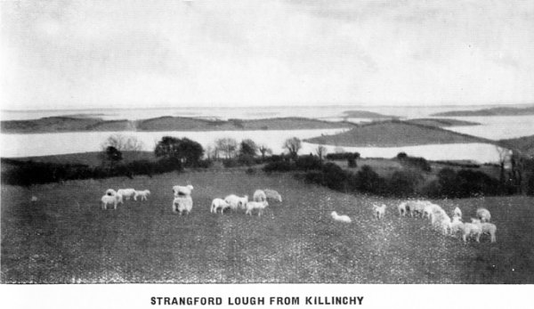
STRANGFORD LOUGH FROM KILLINCHY |
The County of Down.
BY R. LLOYD PRAEGER, D.SC.
| |
"The comely Ards, the pleasant Ards,
Dear land of little hills,
Of bosoming fields, of cresting woods,
Of twisting lanes, where spills
The humble wealth of buttercups
And meadowsweet and ferns ;
Of darkling bogs and Long-dry moss
Where the whin's gold glory burns ;
This is the Ards, the pleasant Ards,
Where the peace of God distills
From the cresting woods, the bosoming fields,
And all the little hills." � ALEX RIDDELL |
AMONG Irish counties, Down
impresses the visitor by its peaceful fertility and pleasant aspect. The
undulating surface is frequently broken into series of little rounded
hills, so that the area has been likened to a basket of eggs. On
hill-top and in valley alike are frequent homesteads, the
 older thatched
and white-washed cottages of former generations steadily giving way to
comfortable two storey houses. Down is sea-girt round two-thirds of its periphery ; the extensive sea inlet of
Strangford Lough lies wholly within it ; Lough Neagh, the largest area
of fresh water in the British Isles, touches its north-eastern edge ;
numerous little lakes lie embosomed among its fertile hillocks, and so
the charm of sea or lake is present almost everywhere. In the centre,
its undulations are broken by a series of heathery hills culminating in
Slieve Croob (1,755 feet) ; and the southern end of the county from
Newcastle to Rostrevor, is occupied by the noble group of the Mourne
Mountains, of which the loftiest, Slieve Donard, attains 2,796 feet. The
little towns which are dotted over the area mostly share in the quiet
which pervades the countryside. Belfast, growing by leaps and bounds,
has acted as a lode-star attracting the younger generation and lessening
the growth of many of the smaller places. But some of these, like
Newtownards, Newry and Ban-bridge, have important factories of their
own, and maintain a sturdy independence, The seaside resorts have
benefited by Belfast's phenomenal growth ; the more the city increases,
the greater is the demand for bracing atmosphere and open air sports,
and so Bangor Donaghadee, Newcastle and Warrenpoint flourish on
Belfast's increase, and prosper in the degree of her prosperity.
Railways and buses transport the traveller to every part of the county,
and the most distant places are now less than two hours' journey from
Belfast.
older thatched
and white-washed cottages of former generations steadily giving way to
comfortable two storey houses. Down is sea-girt round two-thirds of its periphery ; the extensive sea inlet of
Strangford Lough lies wholly within it ; Lough Neagh, the largest area
of fresh water in the British Isles, touches its north-eastern edge ;
numerous little lakes lie embosomed among its fertile hillocks, and so
the charm of sea or lake is present almost everywhere. In the centre,
its undulations are broken by a series of heathery hills culminating in
Slieve Croob (1,755 feet) ; and the southern end of the county from
Newcastle to Rostrevor, is occupied by the noble group of the Mourne
Mountains, of which the loftiest, Slieve Donard, attains 2,796 feet. The
little towns which are dotted over the area mostly share in the quiet
which pervades the countryside. Belfast, growing by leaps and bounds,
has acted as a lode-star attracting the younger generation and lessening
the growth of many of the smaller places. But some of these, like
Newtownards, Newry and Ban-bridge, have important factories of their
own, and maintain a sturdy independence, The seaside resorts have
benefited by Belfast's phenomenal growth ; the more the city increases,
the greater is the demand for bracing atmosphere and open air sports,
and so Bangor Donaghadee, Newcastle and Warrenpoint flourish on
Belfast's increase, and prosper in the degree of her prosperity.
Railways and buses transport the traveller to every part of the county,
and the most distant places are now less than two hours' journey from
Belfast.
In comparison with the average Irish county, the outstanding
feature of Down is undoubtedly its general fertility. The slaty rocks of
the Silurian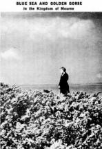 period which prevail have weathered down into a light
friable soil, easy to work. Peat-bog, so prominent a feature of many
parts of Ireland, is here at a minimum. In old days there was enough to
supply much of the county with turf, but now it has all been cut away.
The last remaining bog was the Cotton Moss east of Newtownards, and
there a few traces still remain. Native woods are like-wise a thing of
the past, save around the skirts of the mountains where oak and birch
cling to their ancient home ; but an abundance of trees has been
planted, so that many parts are richly wooded. Some two-fifths of the
area of the county (which is 957 square miles), is under tillage, and
about the same proportion under grass, the principal crops are oats,
potatoes and turnips. Flax, once an important Co. Down crop, now takes a
quite subordinate place ; the lovely bright green waving fields starred
with blue flowers are no longer the familiar sight that they were once,
and the Belfast mills now derive their main supplies from abroad. The
rectangular flax-holes scattered everywhere along the streamlets and the
frequent ruined small scutch-mills bear eloquent testimony to the decay
of what was formerly a leading occupation.
period which prevail have weathered down into a light
friable soil, easy to work. Peat-bog, so prominent a feature of many
parts of Ireland, is here at a minimum. In old days there was enough to
supply much of the county with turf, but now it has all been cut away.
The last remaining bog was the Cotton Moss east of Newtownards, and
there a few traces still remain. Native woods are like-wise a thing of
the past, save around the skirts of the mountains where oak and birch
cling to their ancient home ; but an abundance of trees has been
planted, so that many parts are richly wooded. Some two-fifths of the
area of the county (which is 957 square miles), is under tillage, and
about the same proportion under grass, the principal crops are oats,
potatoes and turnips. Flax, once an important Co. Down crop, now takes a
quite subordinate place ; the lovely bright green waving fields starred
with blue flowers are no longer the familiar sight that they were once,
and the Belfast mills now derive their main supplies from abroad. The
rectangular flax-holes scattered everywhere along the streamlets and the
frequent ruined small scutch-mills bear eloquent testimony to the decay
of what was formerly a leading occupation.
Though Down is less than 50
miles long, it has a coast line of quite 200 miles, due to the deep
indentations of the Loughs of Belfast, Strangford and Carlingford. The
open coast is mostly low and rocky, and in spring is remarkable for its
display of wild flowers ; thrift, sea campion, lady's fingers, bird's -
foot trefoil, the rare little blue squill and other plants combine to
make delightful natural gardens. Elsewhere, as on the Ards coast, around
Dundrum Bay and at the entrance of Carlingford Lough, fine stretches of
sandy beach prevail, beloved of the bather and golfer. At either end of
the Mourne Mountains, near Newcastle and Rostrevor, the hills descend
steeply into the water, and the main road slips through between the
heather and the waves. The coast of the Ards, projecting further to the
east than any other part of Ireland, is low, with dangerous reefs lying
far out to sea, guarded by light-ships and light-houses, and passing
ships give it a wide berth. In the north, Belfast Lough is the old
valley of the Lagan, now sunk beneath the sea. It deepens steadily
towards the open water, and forms a fine natural harbour of refuge. In
the south, Carlingford Lough, on the other hand, has been deepened by
ice action during the glacial period, and, in the manner of fiords, is
deeper inside than at its mouth, which is strewn with reefs.
Down
possesses little history distinct from that of the surrounding counties.
It is associated with Antrim in many of the more stirring episodes, such
as the rebellion of 1798, but one event of surpassing interest can be
claimed by Down ; it was near Downpatrick�a place of note since
prehistoric times�that St. Patrick landed in 432 A.D. He had spent some
years of his youth as a slave at Sliabh Mis (Slemish) in Antrim, and now
re-turned as a Christian Missionary to preach the new faith. These
events are further referred to under the heading of Downpatrick. This
place was also the centre of a conquest of a different kind, for
Downpatrick was the first place in Ulster captured by John de Courcy
when he set out from Dublin in 1 177 to conquer Ulster and bring the
North under the dominion of King John.

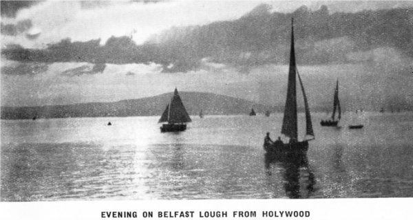
The Belfast Lough
Shore.
The whole of the southern side of Belfast Lough belongs to Down. While
on the opposite Antrim side high hills of dark basalt, occasionally
cliff-walled as on the Cavehill and Knockagh, impend over the water, the
Down side is lower and undulating, very fertile, and from Belfast all
the way to Bangor thickly dotted with demesnes and villas. Beyond
Ballymacarrett, the Down portion of Belfast, and itself a considerable
town, a large residential district extends around Sydenham and Knock.
Holywood,
Four miles down is The Holy (not Holly) Wood, as its ancient
name Sanctus Boscus testifies. Though now mainly a residential suburb of
 Belfast, this place has a long history of its own. A church was founded
here by Saint Laiseran, son of Nasca, in the seventh century, and the
place was called after him Ard-mic-Nasca, the height of the son of Nasca,
later Sanctus Boscus. In the sixteenth century the church was bestowed
on the Franciscans, who established a small monastery; here the site is
marked by the ruins of a later church, surrounded by the older part of
the present graveyard. The most unusual sight which Holywood offers is
the tall Maypole at the intersection of the two principal streets�the
only survivor, it would seem, of the maypoles which once decorated many
an Irish village, especially within the areas of English influence.
Beyond Holywood, a broad band of demesnes and villas stretches along the
shore to HELEN'S BAY, where a sandy shore backed by a golf course
provides an open space in a very lovely neighbourhood. Close by is the
rocky projection of Grey
Belfast, this place has a long history of its own. A church was founded
here by Saint Laiseran, son of Nasca, in the seventh century, and the
place was called after him Ard-mic-Nasca, the height of the son of Nasca,
later Sanctus Boscus. In the sixteenth century the church was bestowed
on the Franciscans, who established a small monastery; here the site is
marked by the ruins of a later church, surrounded by the older part of
the present graveyard. The most unusual sight which Holywood offers is
the tall Maypole at the intersection of the two principal streets�the
only survivor, it would seem, of the maypoles which once decorated many
an Irish village, especially within the areas of English influence.
Beyond Holywood, a broad band of demesnes and villas stretches along the
shore to HELEN'S BAY, where a sandy shore backed by a golf course
provides an open space in a very lovely neighbourhood. Close by is the
rocky projection of Grey Point, with a little fort guarding the entrance
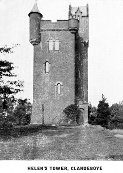
of Belfast Lough. A couple of miles inland is CLANDEBOYE, the seat of
the Marquess of Dufferin and Ava, embracing lakes and wooded hills. On
the highest summit stands Helen's Tower, named after Helen, Lady
Dufferin, grand-daughter of the dramatist, Richard Brinsley Sheridan,
and herself
a poetess of repute. The literary associations of the Clandeboye of her
day are shown by the verses dedicated to her or descriptive of Helen's
Tower and the beautiful prospect which it commands, written by some of
the most distinguished poets of the day � Robert Browning,
Lord Tennyson, Lord Houghton, Rudyard Kipling. Browning's contribution,
which like the others is inserted on the walls of the reception room of
the tower, begins as follows :
Point, with a little fort guarding the entrance
of Belfast Lough. A couple of miles inland is CLANDEBOYE, the seat of
the Marquess of Dufferin and Ava, embracing lakes and wooded hills. On
the highest summit stands Helen's Tower, named after Helen, Lady
Dufferin, grand-daughter of the dramatist, Richard Brinsley Sheridan,
and herself
a poetess of repute. The literary associations of the Clandeboye of her
day are shown by the verses dedicated to her or descriptive of Helen's
Tower and the beautiful prospect which it commands, written by some of
the most distinguished poets of the day � Robert Browning,
Lord Tennyson, Lord Houghton, Rudyard Kipling. Browning's contribution,
which like the others is inserted on the walls of the reception room of
the tower, begins as follows :
"Who hears of Helen's Tower, may dream
perchance
How the Greek beauty from the Scaean gate
Gazed on old friends unanimous in hate,
Death-doom'd because of her fair countenance.
Hearts would leap
otherwise at thy advance,
Lady to whom this tower is consecrate !
Like hers, the face once made all eyes elate,
Yet, unlike hers, was blessed by every glance. . . .
Tennyson's
contribution begins :
" Helen's Tower, here I stand,
Dominant over sea and land,
Son's love built me, and I hold
Mother's love engraved in gold,
Love is in and out of time ;
I am mortal stone and lime. . . .
Lady Dufferin's own contribution may
well rank with these, and was dedicated " To my dear son, on his 21st
birthday, with a Silver Lamp on which was engraved ` Fiat Lux.' "
The
son to whom this poem was inserted had a career of which any noble
mother might be proud. He was a distinguished and honoured diplomat and
statesman, British Embassador at Paris, Rome, Constantinople, and St.
Petersburg in turn, Viceroy of India and Governor-General of Canada, and
in recognition of his services was created first Marquess of Dufferin.
Between Clandeboye and the sea at Helen's Bay is the pretty village of
CRAWFORDSBURN, a favourite place of resort for picnics and teas. The
beautiful fern-filled glen adjoining, belonging to Crawfordsburn House,
can only be entered by permission. A couple of miles to the east we
arrive at the important watering-place of
Bangor.
Now one of the most favoured and favourite watering-places in Ireland,
it has a long and varied history, which divides itself into several very
 different chapters. First a great monastic institution, famous
throughout Europe as a centre of learning and piety. Much later, a small
town populated by English and Scottish settlers, busily occupied in the
cotton manufacture; and finally, coeval with the appearance of the
railroad and the motor car, a villa town, far-flung along the rocky
coast, where bathing, golf, and entertainment have replaced the chanting
of the monks and the rattle of the hand looms.
different chapters. First a great monastic institution, famous
throughout Europe as a centre of learning and piety. Much later, a small
town populated by English and Scottish settlers, busily occupied in the
cotton manufacture; and finally, coeval with the appearance of the
railroad and the motor car, a villa town, far-flung along the rocky
coast, where bathing, golf, and entertainment have replaced the chanting
of the monks and the rattle of the hand looms.
The first chapter is
one of which the town may well be as proud as it is of the last�if two
such different epochs can be compared in any way with each other�a
contrast more startling than that which Thomas Carlyle expounds in his "
Past and Present." The monastery and abbey of Bangor (Beannchor, meaning
in Irish "the pointed hills," literally horns), was founded about 559
A.D. by Comgall, a priest who came of an illustrious family domiciled at
Magheramorne, on Larne Lough. The establishment grew rapidly in
importance under the care of Comgall and his successor, St. Carthagus,
so that St. Bernard wrote of it �"a noble institution, inhabited.by many
thousands of monks, the head of many monasteries, a place truly
sanctified, and so fruitful in saints, which brought forth fruit so
abundantly to God that one of the sons of their holy congregation,
Luanus by name, had himself alone founded one hundred monasteries." For
eight centuries Bangor was one of the most renowned religious centres in
Europe, and sent forth missionaries, many of whom became famous, such as
Gallus, after whom the canton of St. Gall in Switzerland was named, and
the great Columbanus. But at length its prosperity ebbed, and in spite
of the efforts of St. Malachy in the twelfth century, its fortunes
steadily declined. Now all that remains on the site is one piece of old
wall. An ancient bell and a bronze seal still exist, and in Milan is
preserved a priceless manuscript, the book of anthems used in Bangor
Abbey in the seventh century.
manuscript, the book of anthems used in Bangor
Abbey in the seventh century.
The Bangor of to-day has developed, not
around the ancient site (which lay about the present parish church), but
mainly along the breezy, rocky coast around and far to east and west of
Bangor Bay. The main shopping street is still the ancient thoroughfare
that led from the monastery to the sea, but villas, boarding-houses and
hotels extend, to right and left, for two miles, and for some distance
inland.
The rapid growth of the borough is due to its favour-able
position as a summer resort. Facing north, it is sheltered from the
prevailing westerly and south westerly wind, and while on the left is
the opening of the land-locked Belfast Lough, on the right is the open
Irish Sea, with the low fertile coast of Wigtonshire glimmering in the
sunlight only twenty-five miles away. Right opposite Bangor, the Antrim
shore of Belfast Lough
 terminates in the precipitous headlands of the Gobbins and Black Head, on the latter of which a powerful lighthouse
flashes its rapid beacon to passing shipping after sundown, or roars a
tremulous warning when winter fogs lie over the waters. The coast-line
on either side of Bangor, though not lofty, is sloping and rugged, and
provides a highly picturesque shore line.
terminates in the precipitous headlands of the Gobbins and Black Head, on the latter of which a powerful lighthouse
flashes its rapid beacon to passing shipping after sundown, or roars a
tremulous warning when winter fogs lie over the waters. The coast-line
on either side of Bangor, though not lofty, is sloping and rugged, and
provides a highly picturesque shore line.
The hard slaty silurian rocks stand out in rocky points on either
side of the bay, providing deep water which is fully utilized for
bathing at the Pickie and Skipping Stone bathing pools. Half a mile
eastward, Ballyholme Bay offers good smooth sand for those who do not
fancy a "header," and provides an ideal playground for children, both
juvenile and grown-up.
Situated only twelve miles from Belfast, with
an excellent service of both trains and buses, Bangor has two strings to
its bow, for it is a great residential suburb of the adjoining city as
well as a resort for thousands of summer visitors. Owing to its rapid
rise from village to watering-place, Bangor has not, nor never had, a
congested town area. There is a happy absence of anything that could be
called a slum, and the oldest parts are occupied by neat whitewashed
cottages. Fully alive to the advantages of proper town planning, Bangor
initiated a competition for schemes for its development ; the
adjudicator was Professor Abercrombie, who holds the chair of Civic
Design in Liverpool University, and the present lay-out of the sea-front
and its future development are and will remain no haphazard arrangement,
but a well thought-out scheme. That the rapid growth of Bangor calls for
an organised scheme of development is obvious ; the following figures
tell their own tale :�Population, 2,151 in 1871, now 16,000 ; Poor Law
Valuation, �22,567 in 1900, now over �82,000, and increasing by about
�2,000 a year ; bathing (at Pickie alone), 30,000 ten years ago,
now over 100,000. But the most important of all, the number of people
who find health and happiness from a sojourn, whether long or short, in
the sea breezes of Bangor, cannot be estimated.
Golf, too, is a sport
which holds a foremost place here. In 1926 the Borough Council took over
from the Royal Belfast Golf Club their links overlooking the sea at
Carnalea. These were extended to 18 holes, and now make an ideal course
of 5,447 yards. The Bangor Golf Club has
also an 18 hole course of slightly greater length, situated within five
minutes' walk of the railway station. A third excellent golf course is
at Clandeboye, a couple of miles away, ten minutes by bus.
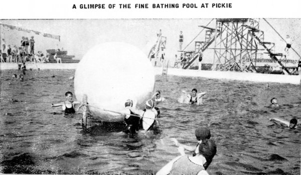
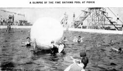
As to
bathing, Pickie provides everything except a sandy beach (for which one
goes to Ballyholme). Here is a very large enclosed pool of all
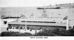 depths up
to 15 feet, with spring boards up to 33 feet above the water ; also open
sea with another set of spring boards. There is space for 1,500
spectators ; if the weather is chilly the dressing boxes are heated by
pipes ; and a cafe and music help to meet the demands of the most
exacting visitor.
depths up
to 15 feet, with spring boards up to 33 feet above the water ; also open
sea with another set of spring boards. There is space for 1,500
spectators ; if the weather is chilly the dressing boxes are heated by
pipes ; and a cafe and music help to meet the demands of the most
exacting visitor.
Bangor Bay, on account of the surrounding hills
being of a uniform height, and the consequent steadiness of the breezes,
is one of the safest boating and yachting grounds in the three kingdoms.
Boating accidents are unknown. A very fine fleet of rowing, sailing and
motor boats is provided, and boats can be hired on reasonable terms.
Yachting reaches its culminating interest in July, when the annual
regatta of the Royal Ulster Yacht Club occupies two days. This event
ranks with the leading regattas of Great Britain, and a long succession
of famous yachts have raced at Bangor. King George V. and before him
King Edward have sent their boats here, and in their time, the Kaiser,
Sir Thomas Lipton and other famous owners. The Commodore is the Prince
of Wales, and it was under the club's flag that the late Sir Thomas
Lipton competed year after year for the America Cup.
Ample facilities
also exist for sea fishing, either from rowing boats in Bangor and
Ballyholme Bays, or from motor or sailing boats in the deeper waters of
the Lough. Close to the shore, rock codling, flat-fish, whiting, blockan
and conger (from the pier), are the principal varieties caught, while
further out lythe, stanlock, gurnard and mackerel are obtained.
The
Borough Council has been careful not to allow excessive building to
restrict unduly the open spaces Which modern life demands, and several
public parks supplement the ample Marine Gardens, which occupy the sea
front on the west side of Bangor Bay. The largest of these is Ward Park,
which has an area of fifty acres, in which are well laid Bowling and
Putting Greens also eight hard Tennis Courts. At the Ballyholme end of
the town adjoining the Seacliffe Road are four hard and three grass
courts, in addition to Putting Greens.
Fancy dress parades for young
and old are organised during the season, and carnivals, band promenades
and fireworks displays are arranged at intervals. Visitors should
consult the free Weekly Guide for details.
Unlike many resorts Bangor
has seafront illuminations on an extensive scale from June until the end
of October. The myriads of coloured electric lamps give Bangor Bay a
festive and fairylike appearance.
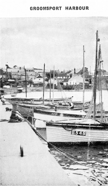
Groomsport,
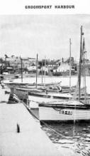 As a centre for those wishing to tour Ulster, Bangor is especially well
equipped, daily or extended tours being available throughout the summer
months. Beyond Bangor, if we follow along the coast past Ballyholme Bay,
we come to the old world village of a quiet spot with good
bathing, boating and fishing, and a picturesque shore, where sand and
rocks intermingle. It was here on the 13th August, 1689, that the
advance army of King William, consisting of 10,000 men, landed from 70
transports, under the command of Duke Schomberg. The present quay is
erected on one originally built by the Danes. Further on, the road cuts
across the base of Orlock Point and an extensive villa suburb leads to a
resort of close on 3,000 inhabitants,
As a centre for those wishing to tour Ulster, Bangor is especially well
equipped, daily or extended tours being available throughout the summer
months. Beyond Bangor, if we follow along the coast past Ballyholme Bay,
we come to the old world village of a quiet spot with good
bathing, boating and fishing, and a picturesque shore, where sand and
rocks intermingle. It was here on the 13th August, 1689, that the
advance army of King William, consisting of 10,000 men, landed from 70
transports, under the command of Duke Schomberg. The present quay is
erected on one originally built by the Danes. Further on, the road cuts
across the base of Orlock Point and an extensive villa suburb leads to a
resort of close on 3,000 inhabitants,
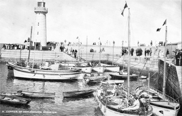
Donaghadee,
with a good harbour. This was a packet-station when the requirements of
cross-Channel traffic were met by steamers
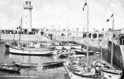 much smaller than those now
in use, the corresponding Scottish port being Port Patrick in Wigtonshire. Now-a-days cross-Channel visitors arrive at Belfast, which
is only 22 miles distant, with ample rail and bus connections to
Donaghadee. There is a beautifully kept golf links here, and the
Council's recent purchase of sixteen acres of land south of the Pier,
which has been laid out as a public park with a Marine Drive,Tennis
Courts and Bowling Greens, has brought this bracing resort thoroughly
up-to-date: There is also a fine harbour, which encourages boating and
fishing. Donaghadee has the lowest rainfall of any spot in the Belfast
district and is in consequence much in demand for day excursions,
especially where parties of children are concerned. Situated on the
coast of the open Irish Sea, with deep water adjoining, the bathing is
exceptionally good. There is a fine bathing pool, with deep open water
for those of a more adventurous spirit. There is also a fine stretch of
sand from which safe bathing may be enjoyed. Good sea fishing is to be
had, and rowing, sailing or speed boats are available for coastal
excursions. From the Rath, an ancient earthen mound crowned with an old
power magazine, and now a public park, a very fine view of the
surrounding country is obtained, stretching from the Antrim Hills to the
Mourne Mountains, and embracing a wide extent of the Scottish coast as
well as the Isle of Man. The Copeland Islands, which are seen lying a
few miles to the north, form a favourite excursion from Donaghadee. On
the outermost low reef of rocks stands a powerful lighthouse. The
largest island is tilled and boasts several comfortable farmsteads.
much smaller than those now
in use, the corresponding Scottish port being Port Patrick in Wigtonshire. Now-a-days cross-Channel visitors arrive at Belfast, which
is only 22 miles distant, with ample rail and bus connections to
Donaghadee. There is a beautifully kept golf links here, and the
Council's recent purchase of sixteen acres of land south of the Pier,
which has been laid out as a public park with a Marine Drive,Tennis
Courts and Bowling Greens, has brought this bracing resort thoroughly
up-to-date: There is also a fine harbour, which encourages boating and
fishing. Donaghadee has the lowest rainfall of any spot in the Belfast
district and is in consequence much in demand for day excursions,
especially where parties of children are concerned. Situated on the
coast of the open Irish Sea, with deep water adjoining, the bathing is
exceptionally good. There is a fine bathing pool, with deep open water
for those of a more adventurous spirit. There is also a fine stretch of
sand from which safe bathing may be enjoyed. Good sea fishing is to be
had, and rowing, sailing or speed boats are available for coastal
excursions. From the Rath, an ancient earthen mound crowned with an old
power magazine, and now a public park, a very fine view of the
surrounding country is obtained, stretching from the Antrim Hills to the
Mourne Mountains, and embracing a wide extent of the Scottish coast as
well as the Isle of Man. The Copeland Islands, which are seen lying a
few miles to the north, form a favourite excursion from Donaghadee. On
the outermost low reef of rocks stands a powerful lighthouse. The
largest island is tilled and boasts several comfortable farmsteads.
Comber.
The main line of the Belfast and County Down Railway starts from Belfast
southeastward down a fertile valley, past the great new Parliament
Buildings, Dundonald with its high flat-topped Norman motte, and on to
Comber, a busy little town with a famous distillery, weaving mills and,
in the Market Square, a lofty monument to Sir Robert Rollo Gillespie, a
dashing soldier of Indian fame, who earned a memorial in St. Paul's
Cathedral. Thence a branch leads through Newtownards to Donaghadee.
Newtownards
is a town of close on 10,000 inhabit-ants, and a centre of all branches
of the linen industry. Hand embroidery is also a chief source of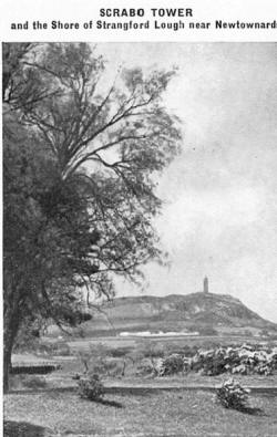 employment. It is a starting place for excursions down the peninsula of
the Ards, and the island-studded sea-inlet of Strangford Lough. Rising
at the south end of the town is the high square tower of the Priory of
St. Columba. A good deal of the thirteenth century work of the original
church still remains and other interesting mediaeval relics in the shape
of Norman grave-slabs may be seen at Movilla, whose abbey�now wholly
ruined�was founded in 540 A.D. by St. Finian, who was connected with
what in our day would have been a famous law-suit. He had brought back
from Rome a copy of the text of the Vulgate revised by St. Jerome, and
this manuscript was transcribed by St. Columba at Dromin, whereupon St.
Finian claimed the copy, The matter was referred to Diarmid, King of
Ireland, whose judgment became famous�" To every cow belongeth her
little offspring-cow, so to every book belongeth its little offspring -
book "� an early application of the principle of copyright.
employment. It is a starting place for excursions down the peninsula of
the Ards, and the island-studded sea-inlet of Strangford Lough. Rising
at the south end of the town is the high square tower of the Priory of
St. Columba. A good deal of the thirteenth century work of the original
church still remains and other interesting mediaeval relics in the shape
of Norman grave-slabs may be seen at Movilla, whose abbey�now wholly
ruined�was founded in 540 A.D. by St. Finian, who was connected with
what in our day would have been a famous law-suit. He had brought back
from Rome a copy of the text of the Vulgate revised by St. Jerome, and
this manuscript was transcribed by St. Columba at Dromin, whereupon St.
Finian claimed the copy, The matter was referred to Diarmid, King of
Ireland, whose judgment became famous�" To every cow belongeth her
little offspring-cow, so to every book belongeth its little offspring -
book "� an early application of the principle of copyright.
St. Columba, however, managed to retain the copy,
which eventually passed into the hands of the
O'Donnells, who, in the eleventh century, had a
beautiful silver shrine made for its reception.
Shrine and book were some-times borne before clans
in war-time as a sort of battle standard.
Fortunately both survived this treatment, and are
now deposited with the Royal Irish Academy.
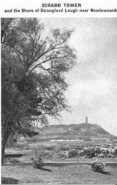
The conspicuous hill of Scrabo rises steeply one
mile south-west of the town, crowned by a lofty
square tower. This was erected in 1858 in memory of
General Charles William Stewart-Vane, 3rd Marquess
of Londonderry, soldier, diplomat and writer. The
hill itself is formed of pink sandstone, capped by
black basalt, and its heathery summit commands fine
views of Strangford Lough and all the neighbouring
region.
The Ards peninsula
The district known as the Ards is the Peninsula 20
miles long running south . from Donaghadee and
Newtownards, with the Irish Sea on one side of it,
and the marine inlet of Strangford Lough on the
other. It is a hillocky fertile pleasing area, with
rocky points and sandy bays along the outer shore,
and a general air of quiet rustic happiness. Until
the advent of the motor car much of it was difficult
of access, and the traveller had to rely on the old
" long car " that ran down the inner shore to
Portaferry. On this route, one passes, five miles
below Newtownards, Mountstewart House, the residence
of the Marquess of Londonderry. Here was born, in
1769, the great Lord Castlereagh, one of the best
abused of British statesmen. There are beautiful
gardens, and a small dolmen near the house marks the
site of a remarkable cemetery of the Bronze Age,
discovered in 1786, when below a cairn of loose
stones sixty or seventy small sepulchral cists built
of slabs of stone, each containing fragments of
burnt bones and charcoal, and in the north-east
corner an earthern urn, were discovered.
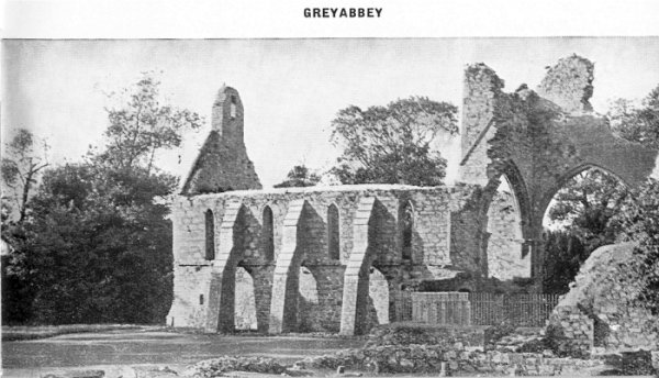
Greyabbey
About two miles further on we reach the village of
where in well-kept private grounds , stand the ruins
of the finest abbey in this
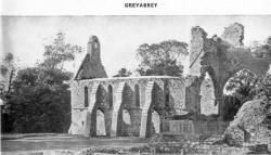 part
of Ireland. The place was founded by Affreca,
daughter of Godred, King of Man, and wife of John de
Courcy, the Anglo-Norman leader, whose name is so
intimately connected with County Down history. It
was built in the early English style, of pink
sandstone from Scrabo Hill, a few miles away. It now
forms a picturesque ruin, carefully preserved by the
Government of Northern Ireland. It was in 1543 that
the abbey was finally abandoned by the Cistercian
monks who had occupied it for three and a half
centuries. Subsequent delapidation appears to have
been hastened by Sir Brian Phelim O'Neill, who,
consequent on the handing over by Queen Elizabeth of
his lands of Clandeboye to Sir Thomas Smith,
destroyed every local building that might have been
of value to the English.
part
of Ireland. The place was founded by Affreca,
daughter of Godred, King of Man, and wife of John de
Courcy, the Anglo-Norman leader, whose name is so
intimately connected with County Down history. It
was built in the early English style, of pink
sandstone from Scrabo Hill, a few miles away. It now
forms a picturesque ruin, carefully preserved by the
Government of Northern Ireland. It was in 1543 that
the abbey was finally abandoned by the Cistercian
monks who had occupied it for three and a half
centuries. Subsequent delapidation appears to have
been hastened by Sir Brian Phelim O'Neill, who,
consequent on the handing over by Queen Elizabeth of
his lands of Clandeboye to Sir Thomas Smith,
destroyed every local building that might have been
of value to the English.
Milisle, Ballywalter and Cloughey.
On the seaward side of THE ARDS, south of Donaghadee,
interspersing the fine marine drive which runs
almost to the apex of the Peninsula at Ballyquintin
Point, are a number of charming villages and
hamlets. First we come to what was formerly an
old-world fishing village�MILLISLE�now an
increasingly popular venue for bungalow dwellers.
There are fine sands here, providing safe bathing
and excellent facilities for young children. Sandy
bays and good bathing can also be had at BALLYFERRIS
POINT and BALLYWALTER, a resort extending In its
popularity as a holiday centre. South of Ballywalter
are the smaller villages of BALLYHALBERT, PORTAVOGIE
and CLOUGHEY. Cloughey has a beautiful strand, and
is a delightful resort for children. Close by at
Kirkiston is a well-kept and sporting golf links.
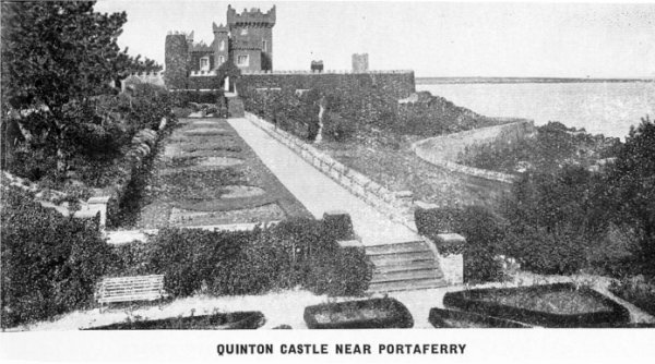
Portaferry.
At the southern extremity of the Ards the quaint
little fishing town of Portaferry faces across the
narrow entrance of Strangford Lough to the
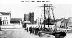 village
of STRANGFORD. Portaferry is a pleasant place, from
which the lower part of the Ards may conveniently be
explored. A ferry connects it with Strangford,
whence one may link up with the railway at
DOWNPATRICK.
village
of STRANGFORD. Portaferry is a pleasant place, from
which the lower part of the Ards may conveniently be
explored. A ferry connects it with Strangford,
whence one may link up with the railway at
DOWNPATRICK.
Strangford Lough.
Towards its eastern edge of the County of Down dips gently below the
sea, and the myriad little rounded hills which are so characteristic of
its surface become a series of little islands and peninsulas, with the
sea water flowing between. The upper end towards Newtownards is shallow,
and the extensive banks exposed at low water are a feeding ground for
innumerable wild fowl. The lower part is deep and open save for the
island-studded estuary of the River Quoile at Strangford in the
south-west.
 In
the south-east beyond Portaferry, the lough assumes
a river-like form, which continues till the open sea
is reached five miles lower down. Through these
narrows a tremendous tide runs in and out. Twice
every day four hundred million tons of green water
rush up into the lough through this deep seething
strait, and down again into the Irish Sea. When the
wind is in the east and the tide is ebbing, the bar
is a very dangerous place. The name that the
Norsemen gave to this lough Strang Fiord, the
violent inlet�is most appropriate. The Irish had
previously named it Loch Cuan, the harbour lake. The
islands of Strangford are of all sizes, down to mere
reefs. The larger ones are farmed or grazed, while
the small ones are a paradise for sea-birds, which
nest in great numbers�gulls, terns, ducks of various
kinds, oyster-catchers, ringed plovers and others.
On MAHEE ISLAND, up against the mainland shore, near
KILLINCHY, stand the ruins of the once important
ecclesiastical establishment of Nendrum. The church
was founded by Mochoe, a disciple of St. Patrick, so
it can claim a very early foundation. The name of
St. Caylan, first Bishop of Down, is associated with
Nendrum, and in the twelfth century it was
handsomely endowed by John de Courcy, already
referred to. Within recent years the site has been
carefully cleared and the ruins conserved, including
the foundations of the church and round tower.
In
the south-east beyond Portaferry, the lough assumes
a river-like form, which continues till the open sea
is reached five miles lower down. Through these
narrows a tremendous tide runs in and out. Twice
every day four hundred million tons of green water
rush up into the lough through this deep seething
strait, and down again into the Irish Sea. When the
wind is in the east and the tide is ebbing, the bar
is a very dangerous place. The name that the
Norsemen gave to this lough Strang Fiord, the
violent inlet�is most appropriate. The Irish had
previously named it Loch Cuan, the harbour lake. The
islands of Strangford are of all sizes, down to mere
reefs. The larger ones are farmed or grazed, while
the small ones are a paradise for sea-birds, which
nest in great numbers�gulls, terns, ducks of various
kinds, oyster-catchers, ringed plovers and others.
On MAHEE ISLAND, up against the mainland shore, near
KILLINCHY, stand the ruins of the once important
ecclesiastical establishment of Nendrum. The church
was founded by Mochoe, a disciple of St. Patrick, so
it can claim a very early foundation. The name of
St. Caylan, first Bishop of Down, is associated with
Nendrum, and in the twelfth century it was
handsomely endowed by John de Courcy, already
referred to. Within recent years the site has been
carefully cleared and the ruins conserved, including
the foundations of the church and round tower.
Killyleagh,
a few miles further south, is a busy little
town standing on the edge of the lough. De Courcy
built a strong castle here, which now, rebuilt
beyond recognition, is the residence of the
Rowan-Hamilton family. Here was born Sir Hans
Sloane, a famous traveller and London physician,
President of the Royal Society and founder of the
British Museum. He died in 1753. Killyleagh makes an
excellent base for the exploration of Strangford
Lough, and for sailing and fishing in these
sheltered waters,
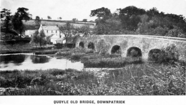
Downpatrick,
for many centuries a place of importance, stands on a hill half
surrounded by the marshes of the Quoile, near the place where that river
becomes tidal and a ford existed in old days. Situated in a fertile area in a
position eminently suitable for defence, a hillock, a little west of the
present town, was selected by some pre-historic strategist as the site
of a huge earthen fort. It was long known as Rath Cealtair, or Dun
Cealtair, the fort of Celtchar. This leader, often referred to in
ancient documents as Celtchar-of-the-Battles, was one of the heroes of
the Craoibh Ruadh, or Red Branch, and a contemporary and friend of
Connor MacNessa, King of Ulster, a famous figure in early history. The
name Rath Cealtair persisted at least until Norman times, for a charter
of John de Courcy refers to Ecclesia Sanctae Trinitatis in Rath Kelter.
The fortress was also known as Dun-leth-glas, a name of obscure meaning,
and in this form ultimately gave its name to the county. Eventually the
name of the patron saint was added, giving the modern designation of
Downpatrick. The connection of the place with the founder of
Christianity in Ireland is not clear. He certainly founded the churches
of Raholp and Saul in this vicinity, and probably that of Downpatrick
itself, and he appears to have been buried here, though there seems to
be little authority for assuming that the actual place of interment was
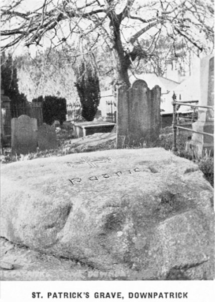
the spot in the graveyard beside the Cathedral from which for a long
time pious pilgrims took away a little
tidal and a ford existed in old days. Situated in a fertile area in a
position eminently suitable for defence, a hillock, a little west of the
present town, was selected by some pre-historic strategist as the site
of a huge earthen fort. It was long known as Rath Cealtair, or Dun
Cealtair, the fort of Celtchar. This leader, often referred to in
ancient documents as Celtchar-of-the-Battles, was one of the heroes of
the Craoibh Ruadh, or Red Branch, and a contemporary and friend of
Connor MacNessa, King of Ulster, a famous figure in early history. The
name Rath Cealtair persisted at least until Norman times, for a charter
of John de Courcy refers to Ecclesia Sanctae Trinitatis in Rath Kelter.
The fortress was also known as Dun-leth-glas, a name of obscure meaning,
and in this form ultimately gave its name to the county. Eventually the
name of the patron saint was added, giving the modern designation of
Downpatrick. The connection of the place with the founder of
Christianity in Ireland is not clear. He certainly founded the churches
of Raholp and Saul in this vicinity, and probably that of Downpatrick
itself, and he appears to have been buried here, though there seems to
be little authority for assuming that the actual place of interment was
the spot in the graveyard beside the Cathedral from which for a long
time pious pilgrims took away a little
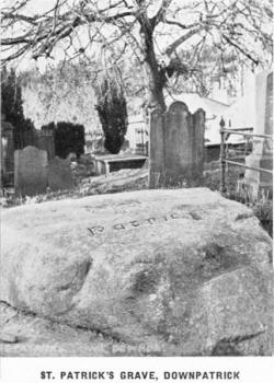 of
the soil, and which some years ago was covered by a great unhewn slab of
Mourne granite with the Saint's name engraved upon it.
of
the soil, and which some years ago was covered by a great unhewn slab of
Mourne granite with the Saint's name engraved upon it.
When John de Courcy in 1177 sallied northward from
Dublin to conquer Ulster with a thousand men at his
back, including twenty-two knights and 300 archers,
he made for Downpatrick, utterly defeated the Irish
under Rury MacDonlevy, King of Ulster, and
established himself firmly here. He founded a
Benedictine abbey, and it is recorded that he
conveyed to Downpatrick church with great pomp the
remains of Brigid and Columba, two of Ireland's most
famous saints, and interred them beside the remains
of their great predecessor, Patrick.
The place subsequently had a stormy history. It was sacked by Edward
Bruce in 1316. The church was rebuilt, but in 1538 Lord Deputy Grey
ravaged Downpatrick, desecrating and destroying the Cathedral. For this
and other outrages he was executed. The Cathedral did not recover from
this blow, and remained in a completely ruined condition till 1790, when
rebuilding was commenced. Unfortunately the round tower that stood
beside the church was removed for fear it might fall and injure the new
structure. The Cathedral, as restored, is a simple building in the
perpendicular style, constructed of the local Silurian slate. Above the
large east window are nitches containing the effigies of the three
saints referred to above, much battered at the hands of Lord Deputy
Grey's troops. Some of the stone capitals, finely carved, are almost all
that survives of the old building.
Downpatrick can boast
some famous names among its ecclesiastics and
townsmen. It has strong claims to have been the
birthplace of Duns Scotus, the great philosopher. In
the twelfth century Saint Malachy was Bishop of Down
for twelve years. Five centuries later Jeremy Taylor
held the same office, and in the last century,
Richard Mant and William Reeves, both of whom did
eminent work in Irish history and archaeology, held
the Bishopric. Battles and burnings through the
centuries have left very little surviving of the old
Downpatrick. The town cross, restored from broken
fragments. has been re-erected outside the east end
of the Cathedral. Of de Courcy's castle, which stood
near the present post office, and of the early
Cistercian and Franciscan houses that existed here,
no trace remains. The tower of the parish church
near the middle of the town dates from 1177. Though
still the county town, Downpatrick is now a small
quiet place, the centre of a fertile rural area,
but it still forms for those of antiquarian tastes
the starting-point for very interesting excursions,
for stone circles, dolmens, old churches and castles
proclaim the importance of the district since
pre-historic times.
First, there is
the great dun already referred to. It stands on low
ground, but before the construction of lock gates
near by, the sea flowed up every tide and almost
surrounded the ancient site, and at low tide
mud-flats made a serious obstacle, so the dun was
better protected than might now appear.
On the other side of the Quoile stand the ruins of
Inch Abbey (Inis, an island). The ancient name of
the place was Iniscouscry, Couscry's Island, after
one of the sons of King Conor MacNessa, who, himself
King of Ulster, was slain here in A.D. 33. John de
Courcy founded a monastery at Inch in 1180 and
brought over Cistercian monks from Cumberland to
conduct it. Though now much ruined, the buildings
that remain display considerable architectural
beauty.
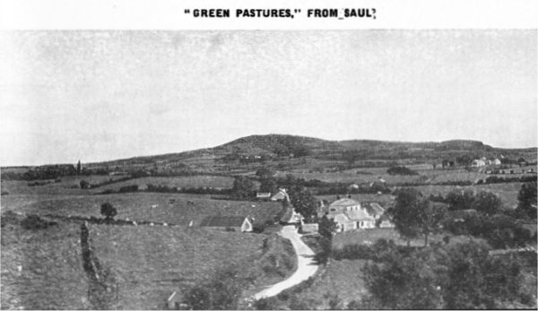
Not far away is SAUL (Sabhal, a barn) where St. Patrick first preached
Christianity in Ireland. The name still commemorates the site of this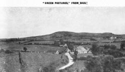 historic event�a barn placed at his disposal by Dichu, the local
chieftain; here a small church was built, which St. Patrick often
visited, and here he died in A.D. 493. The place had a chequered
history, characteristic of early Christian times in Ireland. It was
burnt by the Danes, rebuilt by St. Malachy, sacked by Magnus O'Eochhadha,
King of Ulster, and again in 1316 by Edward Bruce. Now a small plain
church of modern date occupies the site and around it fragments of older
buildings alone remain to speak of its long history. It stands high,
with a fine view in all directions over the fields, woods and waters of
County Down. Other early Christian antiquities are also here the very
early church of Raholp, with clay used instead of mortar ; St. Patrick's
Holy Wells at STRUELL, once a place of resort by rich and poor alike for
the washing away of diseases, and LOUGHINISLAND, where three churches of
varying date stand on a long narrow islet in a pretty lake. Of
prehistoric monuments there is also quite a number about Downpatrick,
among the more interesting being the stone circle at Ballyalton, the
larger one at Ballynoe, and the fine Lough Money dolmen.
historic event�a barn placed at his disposal by Dichu, the local
chieftain; here a small church was built, which St. Patrick often
visited, and here he died in A.D. 493. The place had a chequered
history, characteristic of early Christian times in Ireland. It was
burnt by the Danes, rebuilt by St. Malachy, sacked by Magnus O'Eochhadha,
King of Ulster, and again in 1316 by Edward Bruce. Now a small plain
church of modern date occupies the site and around it fragments of older
buildings alone remain to speak of its long history. It stands high,
with a fine view in all directions over the fields, woods and waters of
County Down. Other early Christian antiquities are also here the very
early church of Raholp, with clay used instead of mortar ; St. Patrick's
Holy Wells at STRUELL, once a place of resort by rich and poor alike for
the washing away of diseases, and LOUGHINISLAND, where three churches of
varying date stand on a long narrow islet in a pretty lake. Of
prehistoric monuments there is also quite a number about Downpatrick,
among the more interesting being the stone circle at Ballyalton, the
larger one at Ballynoe, and the fine Lough Money dolmen.
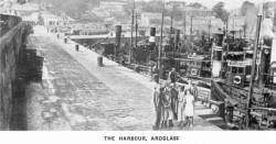
Ardglass an important centre of the
fishing industry , and a breezy, exhilarating place, lies on the rocky
coast of Down, seven miles from
 Downpatrick,
with which it is connected by rail and bus. Around Ardglass the coast is
bolder than is usual in Down, and steep rocks descend into deep water.
The harbour occupies a sheltered creek, with the street of the town
rising above it, and is safe and commodious for the large number of
herring boats of many nationalities which frequent it during the season.
The Anglo-Normans, strongly established at Downpatrick, found this
little port an important link in their sea communications, and built no
less than seven castles at Ardglass for its protection. The place was
later controlled by a trading company which established itself at
Ardglass under a grant from Henry IV. Ardglass was then a corporate town
and Royal borough, returning members to Parliament. Its importance
declined until the advent of the railway, which facilitated the fishing
industry, and also led to the "discovery" of the place by holiday makers
who soon realised the advantages which its open
Downpatrick,
with which it is connected by rail and bus. Around Ardglass the coast is
bolder than is usual in Down, and steep rocks descend into deep water.
The harbour occupies a sheltered creek, with the street of the town
rising above it, and is safe and commodious for the large number of
herring boats of many nationalities which frequent it during the season.
The Anglo-Normans, strongly established at Downpatrick, found this
little port an important link in their sea communications, and built no
less than seven castles at Ardglass for its protection. The place was
later controlled by a trading company which established itself at
Ardglass under a grant from Henry IV. Ardglass was then a corporate town
and Royal borough, returning members to Parliament. Its importance
declined until the advent of the railway, which facilitated the fishing
industry, and also led to the "discovery" of the place by holiday makers
who soon realised the advantages which its open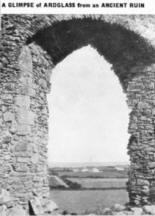 position on the coast and breezy uplands confer. Places of accommodation
sprang up, golf became a leading sport and the picturesque coast to
north and south provided ideal rambles. In the midst of these modern
activities there is plenty to remind the visitor of the bygone
importance of Ardglass. Jordan's Castle, still perfect, and now a kind
of local museum, derives its name from an Anglo-Norman family which
settled here. During the Earl of Tyrone's rebellion in the reign of
Elizabeth it was repeatedly attacked, but successfully defended by Simon
Jordan, and eventually relieved by Lord Deputy Mountjoy. A few miles
north of Ardglass at BALLYHORNAN BAY and KILLARD POINT there are
position on the coast and breezy uplands confer. Places of accommodation
sprang up, golf became a leading sport and the picturesque coast to
north and south provided ideal rambles. In the midst of these modern
activities there is plenty to remind the visitor of the bygone
importance of Ardglass. Jordan's Castle, still perfect, and now a kind
of local museum, derives its name from an Anglo-Norman family which
settled here. During the Earl of Tyrone's rebellion in the reign of
Elizabeth it was repeatedly attacked, but successfully defended by Simon
Jordan, and eventually relieved by Lord Deputy Mountjoy. A few miles
north of Ardglass at BALLYHORNAN BAY and KILLARD POINT there are
fine stretches of sand, beloved by surf bathers and picnickers.
The visitor will delight in the high grassy stretch south of the town,
known as the Downs, where the golf course is situated. The views from
this place, as from the adjoining hill, called the Ward of Ardglass, are
particularly fine, embracing a wide stretch of sea to north, east and
south, the Isle of Man, and grand views of the Mourne Mountains.
Killough, a couple of miles south of
Ardglass, is a straggling village planted with sycamore trees and a
small fishing harbour �a pretty and interesting place.
Especially to be recommended is the walk southward along the rocky shore
to St. John's Point, the northern horn of the large bay of Dundrum. The
coast is delightfully free and open, the rocks full of wild flowers and
populous with birds. At St. John's Point a tall lighthouse forms a
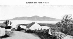
conspicuous land-mark. Thence a winding road leads westward along the
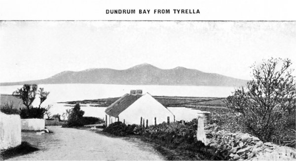
shore and past the beautiful bathing strand at TYRELLA, and the
extensive military camp of BALLYKINLER.
Dundrum, the wide bay of which mention has
been made, faces southward, and is almost wholly fringed with
beautiful sandy beaches. From
 St.
John's Point the bay curves in a great sweep to Newcastle, where the
Mourne Mountains rise steeply from the water. In the middle of the bay a
narrow opening, with sand-dunes on either side, leads to the Inner Bay
of Dundrum, a hammer-headed inlet stretching far to right and left with
the village standing opposite the opening. The bay is shallow, with
sandy and muddy flats beloved of sea-birds of many kinds. The high
sand-dunes along the outer side, and the vicinity of the towering Mourne
Mountains, make Dundrum a very picturesque place. On rising ground
immediately behind the village stand the imposing ruins of Dundrum
Castle. The hill was occupied by a fortress long before buildings in
stone and mortar were known. A great earthen fort occupied the site,
called in the ancient annals Dun Rudhraidhe�Rury's Fort, though who Rury
was is not known. Later it was called Dundrum, meaning the Fort on the
Ridge. In Anglo-Norman times one of the invaders�probably the ubiquitous
John de Courcy himself�replaced the ancient earthen rath by one of the
strongest of the many castles, by the aid of which the English held the
turbulent local tribes in check. As late as 1539, Lord Deputy Grey wrote
to Thomas Cromwell, Lord Privy Seal�" I assure your Lordship, as yt
standyth (it) ys one of the strongyst holtes that ever I sawe in
Irelande, and moost commodios for defence in the hole countre of Lecayle,
both by see and lande." From the earliest times this has been an
historic place. It was at Dundrum that the chief Bricrin "of the
Poisoned Tongue" gave the great feast to King Conor MacNessa and the Red
Branch Knights that is described in the ancient annals, and which had
serious consequences. The building of the Norman castle was an event
already late in the history of the place, and so important a stronghold
proved a bone of contention for many succeeding centuries. Gerald, Earl
of Kildare, wrested it from the Irish in 1517 ; it was captured by the
Magennises, whom Lord Grey ousted from it in 1539 ; Shane O'Neill held
it against the English in 1566, and Lord Mountjoy drove Phelim Magennis
out of it in 1601 ; finally, it was dismantled by Oliver Cromwell in
1652. The ruins are still imposing and display well the lay-out of a
Norman fortress�the massive central donjon, still 50 feet high with
walls 8 feet thick ; the surrounding bawn enclosed in a rough circular
wall of great strength with a deep fosse below it hewn out of the solid
rock, and on the south side, much ruined, the barbican, flanked by
towers.
St.
John's Point the bay curves in a great sweep to Newcastle, where the
Mourne Mountains rise steeply from the water. In the middle of the bay a
narrow opening, with sand-dunes on either side, leads to the Inner Bay
of Dundrum, a hammer-headed inlet stretching far to right and left with
the village standing opposite the opening. The bay is shallow, with
sandy and muddy flats beloved of sea-birds of many kinds. The high
sand-dunes along the outer side, and the vicinity of the towering Mourne
Mountains, make Dundrum a very picturesque place. On rising ground
immediately behind the village stand the imposing ruins of Dundrum
Castle. The hill was occupied by a fortress long before buildings in
stone and mortar were known. A great earthen fort occupied the site,
called in the ancient annals Dun Rudhraidhe�Rury's Fort, though who Rury
was is not known. Later it was called Dundrum, meaning the Fort on the
Ridge. In Anglo-Norman times one of the invaders�probably the ubiquitous
John de Courcy himself�replaced the ancient earthen rath by one of the
strongest of the many castles, by the aid of which the English held the
turbulent local tribes in check. As late as 1539, Lord Deputy Grey wrote
to Thomas Cromwell, Lord Privy Seal�" I assure your Lordship, as yt
standyth (it) ys one of the strongyst holtes that ever I sawe in
Irelande, and moost commodios for defence in the hole countre of Lecayle,
both by see and lande." From the earliest times this has been an
historic place. It was at Dundrum that the chief Bricrin "of the
Poisoned Tongue" gave the great feast to King Conor MacNessa and the Red
Branch Knights that is described in the ancient annals, and which had
serious consequences. The building of the Norman castle was an event
already late in the history of the place, and so important a stronghold
proved a bone of contention for many succeeding centuries. Gerald, Earl
of Kildare, wrested it from the Irish in 1517 ; it was captured by the
Magennises, whom Lord Grey ousted from it in 1539 ; Shane O'Neill held
it against the English in 1566, and Lord Mountjoy drove Phelim Magennis
out of it in 1601 ; finally, it was dismantled by Oliver Cromwell in
1652. The ruins are still imposing and display well the lay-out of a
Norman fortress�the massive central donjon, still 50 feet high with
walls 8 feet thick ; the surrounding bawn enclosed in a rough circular
wall of great strength with a deep fosse below it hewn out of the solid
rock, and on the south side, much ruined, the barbican, flanked by
towers.
The sand-hills, especially those on the southern side of the entrance of
the Inner Bay, have yielded an unusual number of flint and other stone
implements, derived from the sites of pre-historic settlements of the
Neolithic or Early Bronze Ages.
Newcastle stands on a sandy shore at the
eastern end of the broad Bay of Dundrum, between the dunes which stretch
far to the left and the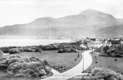 mountains rising steeply from the water's edge on the right. Behind is
well-wooded, pretty, undulating country and heathery hills, so that the
pace offers an exceptional variety of beautiful surroundings. The town
extends along the shore for the better part of two miles, and all the
houses are close to the water. Half way along the main street a trout
stream, the Shimna River, enters the sea. Here in ancient days stood the
New Castle from which the town takes its name, built by Felix Magennis,
head of a powerful local family in 1588. It replaced an older castle,
probably on the same site, of which mention is made in 1433. Old prints
exist showing it standing a hundred and fifty years ago or more, but its
ruins were removed nearly a century ago to make room for an hotel.
Newcastle has never been a centre of business or manufacture, and owes
its present size and importance solely to its natural attractions, which
are unsurpassed anywhere in the British Isles. At the southern end the
houses are actually built on the steep slope of
mountains rising steeply from the water's edge on the right. Behind is
well-wooded, pretty, undulating country and heathery hills, so that the
pace offers an exceptional variety of beautiful surroundings. The town
extends along the shore for the better part of two miles, and all the
houses are close to the water. Half way along the main street a trout
stream, the Shimna River, enters the sea. Here in ancient days stood the
New Castle from which the town takes its name, built by Felix Magennis,
head of a powerful local family in 1588. It replaced an older castle,
probably on the same site, of which mention is made in 1433. Old prints
exist showing it standing a hundred and fifty years ago or more, but its
ruins were removed nearly a century ago to make room for an hotel.
Newcastle has never been a centre of business or manufacture, and owes
its present size and importance solely to its natural attractions, which
are unsurpassed anywhere in the British Isles. At the southern end the
houses are actually built on the steep slope of
 SlieveDonard,which
rises from the water's edge. In the middle of the town, the parish
church erected on a rocky knoll, rises conspicuously near the bridge
over the Shimna River. At the north end is the railway station, and the
very large hotel which the railway company has built in extensive
grounds. Thence one steps at once on to the golf courses, which are
among the finest in the British Isles, and extend far along the sand
hills. The main street lies a little way back from the shoreline, with a
broad wooded promenade constructed between, with pleasant walks and
grass and shady nooks. Newcastle faces east, and, as easterly winds are
rare save in March, trees grow almost to the water's edge. A chalybeate
spring gushes out on the hill above, and is piped down into the town,
where in a grotto near the church its medicinal properties may be
tested. The sea is invariably calm at Newcastle, for the prevailing wind
is westerly, the projecting foot-hills shelter it from the south as the
great sweep of sand shore running to St. John's Point does from the
north The sandy beach is shelving and safe, and for those who prefer a
header, there is plenty of deep water, where the hard slates that lap
round the granite mountains replace the shingle at the south end of the
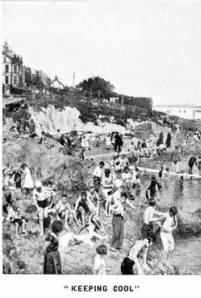
town. The swimming pool recently completed has added to the attractions
of the resort, and over 33,000 persons bathed here in it first season.
SlieveDonard,which
rises from the water's edge. In the middle of the town, the parish
church erected on a rocky knoll, rises conspicuously near the bridge
over the Shimna River. At the north end is the railway station, and the
very large hotel which the railway company has built in extensive
grounds. Thence one steps at once on to the golf courses, which are
among the finest in the British Isles, and extend far along the sand
hills. The main street lies a little way back from the shoreline, with a
broad wooded promenade constructed between, with pleasant walks and
grass and shady nooks. Newcastle faces east, and, as easterly winds are
rare save in March, trees grow almost to the water's edge. A chalybeate
spring gushes out on the hill above, and is piped down into the town,
where in a grotto near the church its medicinal properties may be
tested. The sea is invariably calm at Newcastle, for the prevailing wind
is westerly, the projecting foot-hills shelter it from the south as the
great sweep of sand shore running to St. John's Point does from the
north The sandy beach is shelving and safe, and for those who prefer a
header, there is plenty of deep water, where the hard slates that lap
round the granite mountains replace the shingle at the south end of the
town. The swimming pool recently completed has added to the attractions
of the resort, and over 33,000 persons bathed here in it first season.
The golf links are famous wherever golf is played. The main course has a
total length of 6,490 yards. The wonderful beauty of the surrounding
scenery is undoubtedly a great enhancement even to the enthusiast whose
eye seldom travels far from the ball. Cecil Barcroft, well-known in the
golfing world, has written :�" Everything is big at Newcastle. One stays
in the biggest hotel in Ireland, an iron shot from the first tee ; a big
mountain, the third highest in the land, rises at our back ; a big
course stretches out before us�the grandest links in the kingdom�along
the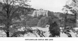 shore of Dundrum Bay, big in length and big in bunkers." The ladies
course, also of 18 holes, is satisfying to the most ambitious player.
For those whose favourite sport is tennis, there are two clubs, and
plenty of both hard and grass courts. Trout fishing also is to be had,
both in the streams and in several lakes in the vicinity. Within a
couple of miles two demesnes of exceptional beauty invite a visit.
Tollymore Park, the seat of the Earl of Roden, lies close up against the
mountains, traversed by the Shimna River, full of water-falls and deep
clear pools, the whole set in ancient oak-woods with a wonderful
undergrowth of ferns, and extensive woods of pine stretch up the
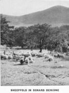
mountain-side. Castlewellan demesne lies a little further north around
the lake of the same name. It is famed among lovers of trees and shrubs
for the fine collection of rare species which have been brought together
here, many of them now of magnificent dimensions. The pleasant little
town of the same name, picturesquely situated among rocky hills, stands
close by.
shore of Dundrum Bay, big in length and big in bunkers." The ladies
course, also of 18 holes, is satisfying to the most ambitious player.
For those whose favourite sport is tennis, there are two clubs, and
plenty of both hard and grass courts. Trout fishing also is to be had,
both in the streams and in several lakes in the vicinity. Within a
couple of miles two demesnes of exceptional beauty invite a visit.
Tollymore Park, the seat of the Earl of Roden, lies close up against the
mountains, traversed by the Shimna River, full of water-falls and deep
clear pools, the whole set in ancient oak-woods with a wonderful
undergrowth of ferns, and extensive woods of pine stretch up the
mountain-side. Castlewellan demesne lies a little further north around
the lake of the same name. It is famed among lovers of trees and shrubs
for the fine collection of rare species which have been brought together
here, many of them now of magnificent dimensions. The pleasant little
town of the same name, picturesquely situated among rocky hills, stands
close by.
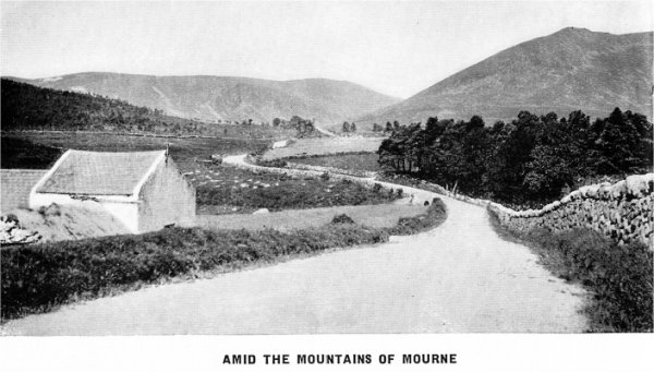
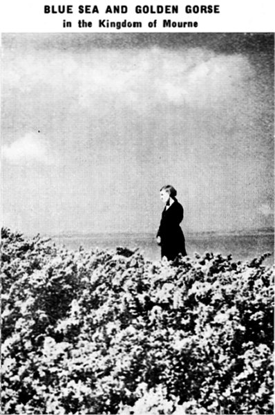
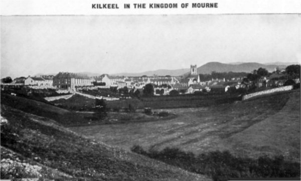
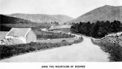
The Kingdom of Mourne. For all devotees of
walking and climbing, and for all lovers of natural beauty, the Mourne
Mountains offer great attractions. They are easy of access, for
Newcastle lies at the foot of the highest peak ; Rostrevor nestles among
its woods, close against the hills at the opposite end ; half. way along
the range on the northern side is the breezy village of Hilltown, from
whence a fine mountain road leads southwards through the mountains to
Kilkeel. Thus if we use these places as centres the mountains can be
tackled from north, south, east or west. These mountains were formed by
an upheaval in the times which geologists call Eocene. A vast mass of
granite protruded from below into the slaty rocks which covered the
country, and broke through them or carried them up so that their
fragments are left stranded on the mountain tops. We have thus a great
granite core, and all round the flanks the slates, altered by the
proximity of the molten granite mass, lap up against the flanks of the
hills. In the course of time the granite hills have mostly assumed the
dome shape which is characteristic of this rock, but two of the
mountains, Slieve Bearnagh and Slieve Bingian are crowned with huge
granite crags. In other places denudation, by ice or otherwise, has
produced fine cliffs, like those on Eagle Mountain, Pigeon Rock
Mountain, and Cove Mountain,
Throughout the eastern half of the range, the slopes are steep, though
seldom precipitous, and the valleys deep, making grand walking for the
mountaineer.
The visitor to the district should not fail to include in his programme
the ascent of Slieve Donard, and it is amusing to compare the
light-hearted way in which the young people of the present day scamper
up a mountain like this, with the serious and apprehensive frame of mind
in which such an adventure was undertaken only a hundred years ago.
Then, John O'Donovan, the Irish scholar, engaged in collecting
information for the Ordnance Survey, made a pilgrimage" to Slieve Donard
"to gratify a curiosity excited in my mind by the gigantic appearance of
the mountain itself from every part of the country." He vividly
describes the "difficult and dangerous" mountain slope, "never since the
creation subdued by hand of cultivation," and "never to alter its
primeval features until the world should be resolved into its ultimate
elements." Some
previous descriptions are positively lurid ! Much earlier than these,
the mountain was selected as a place for meditation and prayer by St.
Domangard (Donard) a disciple of St. Patrick, who built a rude cell and
chapel on the lofty summit, which led to the institution of pious
pilgrimages there until almost the nineteenth century.
Slieve Donard is an easy mountain to climb, for the gradient is fairly
uniform from bottom to top save on the side overlooking the Glen River,
where the Eagle Rock protrudes as a precipitous scarp which should be
avoided. The easiest ascent is by the old tramway a little east of
Newcastle harbour as far as its termination at the quarries, and on over
the spur called Thomas Mountain. From the peak, on a clear day, a
magnificent prospect unfolds itself.
A more beautiful mountain than Slieve Donard, on account of the diadem
of gigantic granite crags which crown its summit, is Slieve Bearnagh, a
couple of miles to the eastward. It also is easy of approach. From
Newcastle we would take the Hilltown road, inland through the pretty
village of Bryansford and on till we are clear of the woods of Tollymore
Park. Keeping always to the left, we cross the Shimna River and turn up
a rough road which ascends a wild mountain valley, in which lies the
Trassey Burn. On our right we pass the huge rock called the Spellack
and�now on the open heather�ascend steeply to the Hare's Gap, between
Bearnagh and Slieve-na-glogh. From this col we get a-grand view into the
heart of the mountains across the head of the Silent Valley, which lower
down contains the great reservoir of the Belfast Water Commissioners.
Our route lies to the right straight up the steep side of Slieve
Bearnagh, over short heather to the great crags that crown the summit,
whence we obtain a very fine prospect, for we are now in the centre of
the range, with the mountains grouped around us on every side.
A short detour from the Hare's Gap in an easterly direction will bring
us to the Diamond Rocks, which lie on the southern slope of
Slieve-na-Glogh.
A rather longer day tour, and a very fine one, embraces the Blue Lough,
and Slieve Bingian, which latter is perhaps the finest individual mountain of the Mourne group. We can go by Glasdrumman to Dunny Water
Bridge, on the Annalong River, whence we traverse for two miles a rough
road used by stone cutters. We cross a rocky knoll which wind and rain
have denuded of its peaty covering, leaving a desert-like expanse of
stone and gravel, and see the Blue Lough in front�a lovely mountain tarn
with high cliffs impending over it on the left and the steep, rocky side
of Slieve Lanagan on the right. From there the ascent of Slieve Bingian
is easy�up a steep slope by a rushing stream to the little Lough
Bingian, and on to the giant crags which crown the summit. The view from
the top is full compensation for our efforts. Less energetic people can
go by car right across the range by the road which traverses the lonely
moor called the Deer's Meadow (where the River Bann has its course), and
down past the cliffs of Pigeon Rock Mountain to Kilkeel. A half hour's
climb to the east when we are half way across the Deer's Meadow will
bring us to one of the finest view-points in the whole district,
overlooking Lough Shanagh. A circular drive right round the
Mournes�embracing Newcastle, Annalong, Kilkeel, Rostrevor, Hilltown and
Bryansford�is strongly to be recommended, as it provides lovely and
changing views of mountain and sea. About midway between Newcastle and
Kilkeel lies the picturesque fishing village of
Annalong. Apart from fishing, its main industry is the dressing
of granite for export. Good accommodation can be had in the
neighbourhood. It is an ideal centre for those desirous of spending a
quiet holiday. A few miles further on and midway between Newcastle and
Rostrevor is the tidy little town of Kilkeel,
also busily concerned with fishing and granite. It is a fine
centre for mountaineering and for both sea and river angling. Kilkeel is
annually becoming more popular as a holiday resort, and good
accommodation is available here.
mountain of the Mourne group. We can go by Glasdrumman to Dunny Water
Bridge, on the Annalong River, whence we traverse for two miles a rough
road used by stone cutters. We cross a rocky knoll which wind and rain
have denuded of its peaty covering, leaving a desert-like expanse of
stone and gravel, and see the Blue Lough in front�a lovely mountain tarn
with high cliffs impending over it on the left and the steep, rocky side
of Slieve Lanagan on the right. From there the ascent of Slieve Bingian
is easy�up a steep slope by a rushing stream to the little Lough
Bingian, and on to the giant crags which crown the summit. The view from
the top is full compensation for our efforts. Less energetic people can
go by car right across the range by the road which traverses the lonely
moor called the Deer's Meadow (where the River Bann has its course), and
down past the cliffs of Pigeon Rock Mountain to Kilkeel. A half hour's
climb to the east when we are half way across the Deer's Meadow will
bring us to one of the finest view-points in the whole district,
overlooking Lough Shanagh. A circular drive right round the
Mournes�embracing Newcastle, Annalong, Kilkeel, Rostrevor, Hilltown and
Bryansford�is strongly to be recommended, as it provides lovely and
changing views of mountain and sea. About midway between Newcastle and
Kilkeel lies the picturesque fishing village of
Annalong. Apart from fishing, its main industry is the dressing
of granite for export. Good accommodation can be had in the
neighbourhood. It is an ideal centre for those desirous of spending a
quiet holiday. A few miles further on and midway between Newcastle and
Rostrevor is the tidy little town of Kilkeel,
also busily concerned with fishing and granite. It is a fine
centre for mountaineering and for both sea and river angling. Kilkeel is
annually becoming more popular as a holiday resort, and good
accommodation is available here.
 From
Kilkeel the main road, keeping westward now, passes at a distance of a
few miles the entrance of Carlingford Lough, guarded by the ancient
stronghold of Greencastle and by a tall lighthouse. Greencastle was an
important fortress of the Anglo-Normans, and had the tempestuous history
associated with places of its kind, and the De Burgos, Edward Bruce and
other local magnates or invaders in turn held it or assaulted it. Lovely
Carlingford Lough is now fully open before us, and the views as we
proceed are of a very high order of beauty. Beyond Killowen, the
southern end of the Mourne Mountains descends steeply into the Lough
covered with woods of old native oak, and these continue till the
sheltered village of Rostrevor is reached
with the large hotel, owned by the Great Northern Railway Company,
facing the sea close by.
From
Kilkeel the main road, keeping westward now, passes at a distance of a
few miles the entrance of Carlingford Lough, guarded by the ancient
stronghold of Greencastle and by a tall lighthouse. Greencastle was an
important fortress of the Anglo-Normans, and had the tempestuous history
associated with places of its kind, and the De Burgos, Edward Bruce and
other local magnates or invaders in turn held it or assaulted it. Lovely
Carlingford Lough is now fully open before us, and the views as we
proceed are of a very high order of beauty. Beyond Killowen, the
southern end of the Mourne Mountains descends steeply into the Lough
covered with woods of old native oak, and these continue till the
sheltered village of Rostrevor is reached
with the large hotel, owned by the Great Northern Railway Company,
facing the sea close by.
Rostrevor is a lovely spot, famous for the mildness of its climate. The
great collection of exotic shrubs and trees that Sir John Ross of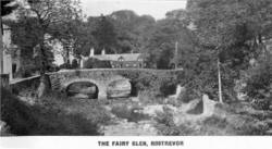 Bladensburg made here included many which in England can only be grown
in Devon and Cornwall, within the influence of the warm Atlantic. The
beautiful woods of native oak or of planted pines which rise in all
directions increase the shelter and the westerly winds which come in
from the open Lough are lessened and tempered by the high ridge of
Carlingford Mountain on the opposite side of the water. All the
favourite recreations may be indulged in here, but best of all are the
many lovely walks that extend in every direction, especially those which
take the visitor up through the woods to where Cloughmore, the " Big
Stone," a glacial erratic weighing some 40 tons, is perched on a
projecting spur, which commands a glorious prospect, or on higher and
over the grassy summits that dominate this portion of the Mourne range.
The tall obelisk which rises conspicuously beside the road on the
Warrenpoint side of Rostrevor commemorates Major General Robert Ross, a
famous Irish soldier, who fought in the American War of Independence,
winning the Battle of Bladensburg against a much superior force of
United States troops, and capturing Washington, only to be killed in an
attack on Baltimore three weeks later.
Bladensburg made here included many which in England can only be grown
in Devon and Cornwall, within the influence of the warm Atlantic. The
beautiful woods of native oak or of planted pines which rise in all
directions increase the shelter and the westerly winds which come in
from the open Lough are lessened and tempered by the high ridge of
Carlingford Mountain on the opposite side of the water. All the
favourite recreations may be indulged in here, but best of all are the
many lovely walks that extend in every direction, especially those which
take the visitor up through the woods to where Cloughmore, the " Big
Stone," a glacial erratic weighing some 40 tons, is perched on a
projecting spur, which commands a glorious prospect, or on higher and
over the grassy summits that dominate this portion of the Mourne range.
The tall obelisk which rises conspicuously beside the road on the
Warrenpoint side of Rostrevor commemorates Major General Robert Ross, a
famous Irish soldier, who fought in the American War of Independence,
winning the Battle of Bladensburg against a much superior force of
United States troops, and capturing Washington, only to be killed in an
attack on Baltimore three weeks later.
 Warrenpoint.
This favourite watering-place stands . on a projecting area, once a
rabbit warren (whence its name), near where the deep valley, down which
the Newry River flows, expands into the sheltered waters of Carlingford
Lough. The situation is superb, facing the entrance of the Lough, with
Rostrevor Mountain and Carlingford Mountain standing sentinel on either
side. Rostrevor, at the base of the mountains, is only a few minutes by
bus, so that the many beautiful walks that lie around the Kilbroney
valley and the adjoining hills are fully accessible.
Warrenpoint.
This favourite watering-place stands . on a projecting area, once a
rabbit warren (whence its name), near where the deep valley, down which
the Newry River flows, expands into the sheltered waters of Carlingford
Lough. The situation is superb, facing the entrance of the Lough, with
Rostrevor Mountain and Carlingford Mountain standing sentinel on either
side. Rostrevor, at the base of the mountains, is only a few minutes by
bus, so that the many beautiful walks that lie around the Kilbroney
valley and the adjoining hills are fully accessible.
Warrenpoint, although almost surrounded by the Mourne Mountains and the
Carlingford Hills. is not relaxing ; in fact, it is probably the most
invigorating place on Carlingford Lough.
Along the front an Esplanade has been erected, in the centre of which
are the fine Municipal Open Air Swimming Baths, in which bathing can be
enjoyed at all states of the tide. These baths furnish access to the
open sea. In connection with the baths, there is a large suite of
private hot sea water baths.
The town possesses a very popular 18-hole Golf Course, which was
enlarged under the supervision of Capt. Lionel Hewson, M.V.0., the
well-known Golf Architect. The course is open on Sundays.
A new Bowling Green has been opened at Slieve Foy Place ; Putting is
also available in the same grounds. The Municipal Gardens, close to the
sea front, are a great asset to the town, and invoke the admiration of
visitors. In these gardens are the public Tennis Courts, also an
artistic Band Stand, where Concert Parties entertain throughout the
season.
The town is a good centre for motor tours, which include some of the
finest drives in Ulster through the Mourne Mountains.
The angler is also catered for at the Old Reservoir, which the Council
has stocked with trout, a small fee being charged. In addition, trout
angling can be had in the district in the Moygannon, Rostrevor, Bann,
Clanrye and Two-mile Rivers, coarse fishing being available in the Newry
Canal.
There is a large fleet of rowing and sailing boats for hire, and boating
is a favourite pastime here on account of the enclosed waters of the
Lough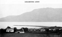 which are seldom disturbed by high wind. Excursions can be arranged to
Rostrevor, Carlingford, Omeath, Narrow Water Castle.
which are seldom disturbed by high wind. Excursions can be arranged to
Rostrevor, Carlingford, Omeath, Narrow Water Castle.
Carlingford is a delightfully picturesque old village lying on the
southern side of the Lough at the foot of the mountain of the same name.
This is an historic place, important long before more popular places
around it were heard of. The Anglo-Normans erected here one of the
strongest castles which they built in the north-east, and one of the
earliest, dating as it does from 1210. Under the name of King John's
Castle it still stands, forming an imposing ruin overlooking the
harbour. There are also the remains of an abbey, and a number of other
interesting relics of the past scattered among the modern houses. In the
opposite direction where the tidal Newry River makes a sharp bend not
much more than a mile above Warrenpoint, Narrow Water Castle stands
within an encircling wall guarding the passage which leads inland to
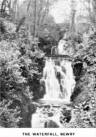 Newry,"
the Gap of the North " is a centre for the famous Carlingford Lough and
Mourne Mountain district. It is one of the most progressive and
up-to-date towns in Ulster, and stands at the head of the Lough amid a
wealth of beautiful scenery, equally attractive to the sportsman, health
seeker and antiquary. The town is one of the most ancient in Ireland,
and on account of its position on the Border of the Pale it has
witnessed many stirring historical events. Within reach of Newry are
early Christian and Pre-Christian remains. St. Patrick is said to have
planted a yew tree here, from which fact the town derives its coat of
arms and name. An abbey was founded in Newry in 1140 A.D. by St.
Malachy, and many traces of it are still to be found.
Newry,"
the Gap of the North " is a centre for the famous Carlingford Lough and
Mourne Mountain district. It is one of the most progressive and
up-to-date towns in Ulster, and stands at the head of the Lough amid a
wealth of beautiful scenery, equally attractive to the sportsman, health
seeker and antiquary. The town is one of the most ancient in Ireland,
and on account of its position on the Border of the Pale it has
witnessed many stirring historical events. Within reach of Newry are
early Christian and Pre-Christian remains. St. Patrick is said to have
planted a yew tree here, from which fact the town derives its coat of
arms and name. An abbey was founded in Newry in 1140 A.D. by St.
Malachy, and many traces of it are still to be found.
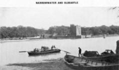 The
district around Newry is teeming with historical memories. Slieve
Gullion, the "most storied mountain in Ireland " ; Foughart, said to be
the birthplace of St. Brigid; Carlingford, etc., all famous in history.
Narrowwater Castle, which occupies a commanding position on the river
bank between Newry and Warrenpoint. and was the scene of many warlike
encounters is well worthy of a visit also the modern castle with its
beautiful ground: and park�the seat of the Hall family. There are many
facilities for visiting the places of interest about Newry, and special
mention should be mad( of the railway and coat} tours around the coast,
via Warrenpoint, Rostrevor Kilkeel, Newcastle, etc
The
district around Newry is teeming with historical memories. Slieve
Gullion, the "most storied mountain in Ireland " ; Foughart, said to be
the birthplace of St. Brigid; Carlingford, etc., all famous in history.
Narrowwater Castle, which occupies a commanding position on the river
bank between Newry and Warrenpoint. and was the scene of many warlike
encounters is well worthy of a visit also the modern castle with its
beautiful ground: and park�the seat of the Hall family. There are many
facilities for visiting the places of interest about Newry, and special
mention should be mad( of the railway and coat} tours around the coast,
via Warrenpoint, Rostrevor Kilkeel, Newcastle, etc
The River Bann, at Hilltown, about ten miles from Newry, is a well-known
trout river.
There are omnibus services to Hilltown from Newry, Newcastle, and
Warrenpoint. There are many historical objects in the districts,
including the old Clonduff Church, and a famous cromlech, in the
townland of Goward, a short distance from Hilltown.
So far this chapter has dealt mainly with the regions bordering on the
coastline, but it is true that the interior of County Down holds great
interests for the visitor as well as an alluring beauty.
Banbridge
 From
Newry the main road to Belfast leads inland to Banbridge. Here the
tourist will see a typical Ulster country town. This flourishing centre
of the linen industry is picturesquely situated on the Upper Bann, about
20 miles from Belfast. Many enterprising manufactories of linen are
From
Newry the main road to Belfast leads inland to Banbridge. Here the
tourist will see a typical Ulster country town. This flourishing centre
of the linen industry is picturesquely situated on the Upper Bann, about
20 miles from Belfast. Many enterprising manufactories of linen are
in the neighbourhood, also extensive bleach-greens.
The fabric for the making of which Ulster is so famous can, at all
seasons of the year, be seen spread out over the fields to bleach.
Tourists are allowed, on application being made, to see how the
manufacture of the unequalled Ulster damask linen is carried on at the
works in the town of the world-famed firm of linen manufacturers�Messrs.
Robinson & Cleaver, Ltd.
Banbridge is in the parish of Seapatrick, and the ruins of the old
church may still be seen in a graveyard about a mile away. This very
ancient ecclesiastical site is said to have been founded by St. Patrick.
What was probably a holy well may be viewed beside the grave-yard. The
River Bann flows by in the valley, and here we feel ourselves to be at
one of the cradles of Christianity in Ireland, and we can appreciate the
beauty of the spot that attracted the Patron Saint to the land.
There is a constant service of railway trains and motor buses to and
from Banbridge.
Lovers of sport are here in a congenial atmosphere. The local links are
a nine-hole course, well laid out and carefully kept up. Visitors are
made welcome at the cheap rate of two shillings a day, or seven
shillings and sixpence a week. A cricket field and tennis courts are
pleasantly situated in the town. Tennis can be had at a nominal charge.
The Bann affords excellent brown trout fishing (free) for a stretch of
about twelve miles, and the pike fisher can find his quarry awaiting him
in the Corbet Lake, about two miles distant.
In the church square, opposite the house in which he was born in 1796,
stands a striking monument to one of the town's most distinguished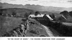 sons�Captain Francis Rawdon Moira Crozier, R.N. The best authorities
award Crozier the fame of having discovered the North-West Passage.
Still following the main road we come to in the heart of County Down. It
is Dromore, notable for its ecclesiastical
history, and
sons�Captain Francis Rawdon Moira Crozier, R.N. The best authorities
award Crozier the fame of having discovered the North-West Passage.
Still following the main road we come to in the heart of County Down. It
is Dromore, notable for its ecclesiastical
history, and
buried in the Cathedral are Bishop Jeremy Taylor, the author of "Holy
Living," one of the great churchmen in history, and Bishop Percy, of
whom Johnson said, "A man out of whose company I never go without having
learned something." The oldest feature about Dromore is doubtless what
is called "The Mount," a great earthen mound whose construction is lost
in the ages of the past. This monument was probably erected for
sepulchral reasons and afterwards used as the scene for ceremonial
gatherings and judicial functions of the ancient Irish. Dromore was the
site of the first Christian settlement founded by St. Colman, who was
the first bishop and abbot of the religious community about the end of
the 5th century. His pillow stone is still preserved at the Cathedral
and the High Cross of County Down granite originally erected by some of
his successors has been repaired and now stands in the graveyard. Gill
Hall, until recently the seat of the Earls of Clanwilliam, is also
notable as the scene of one of the most remarkable ghost stories in the
history of Ulster.
The town itself, which is picturesquely situated on the River Lagan, is
prosperous, and important fairs and flax markets are held periodically.
Very good fishing can be had in the district on the rivers Lagan and
Upper Bann.
Dromara, a few miles south-east lies in the
very centre of the flax-growing , district of Ulster. In the summer it
is a most beautiful sight to see fields of flax in full blossom. This
district has somehow been over-looked by the tourist, yet it is, without
question, one of the most beautiful in the county. Perhaps indeed it is
just the fact that it is off the beaten track which gives it special
charm. Good angling is to be had in the vicinity, and the rambler will
find delight in climbing Slieve Croob and the surrounding hills.
Ballynahinch, a few miles east of
Dromara, where there is an old established spa, with two
springs�one chalybeate � and the other sulphurous. These springs are now
under new management, and greatly improved facilities have been provided
for "taking the waters." In addition, suites of hot sulphur baths have
been installed for the convenience of patrons.
Close by is a well kept Maze, which is said to be longer and more
intricate than the famous one at Hampton Court. Five miles from here is
Slieve Croob ("the mountain of the hoof"), a bare and gaunt mountain.
There are five great cairns on its summit, and two and a half miles
away, in the townland of Legananny, is a remarkable cromlech standing on
a slope to the west of Boley Lough.
Some of the loveliest views in the whole of County Down are obtainable
in this district, and at "The Spa" there is an excellent golf links. The
Lagan, which rises near by on Slieve Croob, is well known to anglers for
its trout. Close by is Begney Lake, where very large pike have been
caught, while in the district there is plenty of shooting�grouse,
partridge, duck and snipe.
Returning to the main road from Dromore to Belfast, the last place of
importance before crossing the boundary into County Antrim, is
Hillsborough, a pretty village built on a
steep hill. It has a fine park, enclosing a 17th century fort, in
which William III. is said to have slept in 1690, and which is visited
by large numbers of tourists. On the hilltop stands a monument to the
4th Marquis of Downshire.
The Maze Racecourse, an historic venue, has long been associated with
Hillsborough.
The official residence of the Governor of Northern Ireland is now
situated at Hillsborough. Hillsborough Castle, formerly the property of
the Marquess of Downshire, was purchased by the Imperial Government in
1924 and is now Government House, Northern Ireland, and is occupied by
His Grace the Duke of Abercorn, K.G., K.P., the first Governor.
The following members of the Royal family have stayed at Government
House :�In 1928 the Princess Royal, then Princess Mary Viscountess
Lascelles, visited there in October, and visits have since been paid by
His Royal Highness the Prince of Wales, on the occasion of his State
Visit to Northern Ireland in November, 1932 ; by Her Royal Highness
Princess Alice, Countess of Athlone, on the occasion of the opening of
the Bazaar in aid of the Ulster Division in October, 1933, and lastly by
His Royal Highness the Duke of Gloucester for the opening of The King's
Hall of the Royal Ulster Agricultural Society in May, 1934, and shortly
after he had been created Earl of Ulster.