|
|||||||||||||||||||||||||||||||||||||||||||||||||||||||||||||||||||||||||||||||||||||||||||||||||||||||||||||||||||||||||||||||||||||||||||||||||||||||||||||||||||||||||||||||||||||||||||||||||||||||||||||||||||||||||||||||||||||||||||||||||||||||||||||||
|
Minutes of the Poor Law Guardians at Lisburn provide some indication of the course of events that probably affected residents in the Dunmurry area during the Famine years30. Attention was first drawn to the potato disease in minutes from November 1845 and to potato crop losses in January 1846. Reduced grain harvests followed in the same year. Poor potato crops in 1847 and potato blighting were next experienced in 1848. In the meantime the occurrence of typhus fever, the need to provide outdoor relief, the rising cost of foodstuff and then the onset of cholera in January 1849 were indicative of other adversities to be endured. Four mitigating factors could have helped the local populace to cope with this situation, about Dunmurry. Firstly, as the 1856 agricultural statistics suggest31, there was a useful range of grain crops, root crops and livestock available in the Lisburn Union area at this period. Secondly, and in spite of an 1847 setback in the linen trade, the innovating introduction of wet spinning and then steam driven machinery sustained job and wage prospects in the local linen industry. Thirdly, the rise and then fall in Dunmurry's townland population between 1841-51 and 1851-61 did not affect the village totals. This fluctuation may well have reflected an influx and dispersion of short stay migrants, from the west of the province. Fourthly, the rise in foodstuff prices could at least be offset by the fact that a significant number of local residents were wage earners (low though the wages were) through involvement with trades or textiles and thus were not overdependent upon agriculture32. (See Figure 4.) The 1901 Census data allow some interesting comparisons to be made across Dunmurry townland. Households with 9 to 12 members were not uncommon at this time. Textile jobs were now especially significant for local residents as was the decline in farming activities. Indeed the 1901 population data on Forms B2 and N1* suggest that 41 farms in the district employed 50 males. In spite of variations across the district 46% of jobs were in textiles, 30% were in a diversity of occupations but only 7% were engaged by agriculture. (See Table 1 – Population Characteristics.) 61% of households in one part of Dunmurry village had at least one member engaged in textile work while 65% of households in the other (Shankhill) section had a similar involvement. 46% of households in the rural Shankhill section had one member in textiles compared to 25% of households in the rural Drumbeg segment. (By 1960 less than 2% of the residents worked in local textile mills while another 4% were engaged in the making up of textile goods. Agricultural employment now accounted for only 1/2% of the local labour. Even more striking, at this date was the fact that only 18% of Dunmurry residents worked there whereas Belfast provided work for 60% of the local labour.) On the land it is known that wheat and hay crops belonging to Mr. Weir of Dunmurry were harvested in 1796, at which date there was also a grain mill in the village. Wheat, oats, potatoes and flax were grown on the better ground of Killeaton and Kilmakee townlands in 1837 and mostly on 10 to 30 acre farms. Not surprisingly cattle were grazed on suitable hill slopes in Derriaghy parish, as occurred on Collin, Aughrim and White Mountain33. Both wheat and flax were grown on
Seymour Hill demesne early in the 19th century where it
was a later asserted that a suitable crop sequence on
the better soils involved grass, oats, potatoes or
turnip followed by wheat, flax and clover hay. On the
poorer soils grass, turnip and wheat crops were
excluded. (Such sequences were similar to those observed
by Dubourdieu in 1812.) The availability of grain crops
on 15 to 30 acre farms in Dunmurry townland was secure
enough to promote flour milling in the village beside
the Glen burn, at the foot of Mill Hill. This water
driven installation was to be augmented by steam driven
machinery during the 19th century.
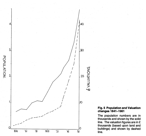
It now needs to be recalled that by mid century farm sizes tended to become larger down the Lagan valley, towards Belfast. Land given over to vegetables increased in the same direction as did the percentage of the farmland which was actually cropped. The Ulster tenant right custom led onto progressive Land Acts between 1870 and 1880 just as the consequences of the 1849 Encumbered Estates Act must have had beneficial results for local land interests, since it involved 30,000 acres of land belonging to the Donegal family. Change is surely reflected in the official records, which referred to local lessors and occupiers of land in 1862 but then to some of them who had become owners of land by 1876. (See Table 2.) As might be expected valuation records for this district moved in sympathy with the growth of the local economy, population, building numbers and changes in the value of money. (See Figure 5.) While the rate of change in the valuation of land and buildings was a measured one in the 19th century the rate of increase was less predictable in the 20th century. Between 1851 and 1901, for example, the district valuation had grown 3 times whereas valuations for the same area increased 5 times between 1911 and 1961.
The 1834 District records34 for property and land valuations in the Drumbeg parish segment of Dunmurry list 14 sizeable houses, a Presbyterian meeting house, corn mill, beetling mill and offices with a total valuation of £278-3-0. A total valuation of £444-19-2 was placed on 460 acres of land and involved 35 entries. In 1835 that part of the townland within Shankhill parish amounted to 362 acres and here 8 sizeable house were assessed at a total of £192-2-0, while 11 holdings were collectively assessed at £425-0-10. The 35 holdings in Drumbeg parish
contained parcels of land ranging in size from 1 to 54
acres (with the 1 acre plots usually recorded as rough
pasture or waste ground). Valuation rates per statute
acre ranged from 9/- on steep or wet ground to 25/- on
good soil with low slopes. Land parcels on holdings in
Shankhill parish ranged from 2 to 45 acres. Plots of 1
to 5 acres frequently were associated with cold, wet or
clayey sites. Ground with adverse characteristics were
assessed at 10/- per statute acre while the best land
was assessed at 28/-per acre.
From the surveyors' notebooks it is
clear that limited adjustments, downwards, were
possible. Industrial installations in the district used
basalt and bricks in their construction and earned their
own assessments. A beetling mill and its water needs,
for example, could be assessed at £10-6-0, whereas a
corn or flour mill using both water and steam power
merited £66. On the other hand a site engaged in
lapping, carding, bleaching and blueing activities was
assessed at £70. By 1862 the Rateable Annual Valuation35 (R.A.V.) for land in the Drumbeg segment of the townland averaged £1-16-0 per acre but actual amounts ranged from £1 to £2-5-0 per annum depending on site factors. The average R.A.V. for a small house was £2-6-0 while house and yard combinations averaged £3-5-0 and house plus small garden averaged £2-12-0. Land only in the Shankhill segment averaged £1-12-0 per acre while actual amounts ranged from £1 to £24-0 per annum. Average R.V.A. for a small house amounted to £1-8-0 while a house and garden combination averaged £1-19-0. The 465 acres in Drumbeg parish was now assessed at £844-9-0 for land and £954-11-0 for buildings. The Shankhill segment of 359 acres produced an R.A.V. of £616-10-0 for land and £402-5-0 for buildings. As might be expected the valuations on buildings associated with textiles and milling had also increased at this date. There were now 60 houses in the village area, 50 in the rural part of Drumbeg parish and 53 in the rural Shankhill segment and yet only 8 families and 2 commercial enterprises had become involved with 716 acres of the townland. This valuation data also indicated that a lessor of land frequently allowed it to be subdivided into plots that were to be used for building purposes as well as for farming, e.g. Marquis of Donegal, J. Hunter, J. McCance, R. Moat and W. Charley.
An official return of owners of land of one acre and upwards in Ireland36 reemphasized the fact that control of land still rested with comparatively few families (20) in Dunmurry district 14 years later. Ten holdings, in and about the village, accounted for just over 700 acres at an average valuation of £12-3-0. Although the largest holdings did not have the highest value per acre it is obvious that land use potential, location and accessibility were significant to assessments. (See Table 2.) Tithe records provide an additional insight into land valuations hereabouts37. Tithes were based upon one tenth of the produce of the land and its livestock being donated to the church annually. They were first made compulsory, then replaced by money equivalents before becoming rent charges. Following Disestablishment in 1869 they were to be changed once again. Of interest here is the fact that the
tithe evaluation of 1830 for the Drumbeg portion of
Dunmurry townland listed 15 family names, accounting for
428 out of 437 acres in 44 plots of mostly arable land. In 1993 Megan McManus published a paper38 on "The function of small Ulster settlements in 1854, 1899 and 1916", the contents of which are relevant to the village of Dunmurry. The writer was concerned with settlements with populations between 500 and 1000 persons, 1000 to 1500 residents and 1500 to 2000 inhabitants. The number of different functions in these settlements is not to be confused with the number of outlets in each settlement providing these functions. While Dunmurry village did not qualify for consideration in 1854 it certainly did by 1899, with a population just below 1000. At that date the village residents provided 30 distinctive functions and as with several comparable villages one person occasionally provided two different services. The institutionalized functions of a post office, church, doctor, dispensary, school and police station were present as were the basic services of a blacksmith, tailor, grocer, farmer/dairyman, painter, shoemaker, joiner, saddler, coal agent, builder, clergyman, teacher and publican. Unusually the village was an established location for linen manufacture, involving spinning, print and dye works with an array of jobs for textile workers. The services of a district nurse, railway station master, hotellier, insurance agent, nurseryman and architect were equally distinctive and further reflected the presence of manufacturing, agricultural, professional and commercial activities associated with it. Three of these functions, to meet the educational, health and religious needs of local people, deserve further attention at this point. Ministry of Education maps of National Schools for the 1855 to 1906 period* show Trinity and Stevenson schools in Dunmurry with others nearby at Finaghy, Derriaghy, Drumbeg and Suffolk. The first single roomed school, located opposite the Non Subscribing Church, in Dunmurry was to be superceded by the end of this period. Nevertheless it was only in 1831 that funds were officially provided for the widespread education of children. To this end grants were made available to schools provided money was raised locally to defray the cost of teachers, equipment and building maintenance. Correspondence on behalf of parents in this townland indicates that the first school and school teacher's house, along with 82 enrolled pupils, was "taken into connexion by the Education Board" on December 20th 183239. The average annual total of scholars was 76 between 1832 and 1843, of whom 50 were boys and 26 were girls. Numbers declined in the last decade of the 19th century and in spite of attempts to amalgamate with Trinity school it was decided to remove it by June 1909. During the lifetime of this school it was staffed by a principal and an assistant teacher, it was subject to annual inspection and its pupils were multidenominational. Both the Stevenson and Trinity schools dated from the end of the 19th century and they were located at opposite ends of the village. The former resulted from a family benefaction while the latter was associated with the Presbyterian church. Between 1896 and 1914 the average annual intake at Stevenson was 50, half of whom were boys. At the outset scholars were Protestant (and mostly Church of Ireland) but Roman Catholic pupils began to attend this school in 1901. Most pupils resided in the village but numbers did attend from Finaghy, Derriaghy, Seymour Hill and Drumbeg. By the outbreak of World War I the teaching staff had been raised from 2 to 3. School intakes at Trinity averaged 49 per year between 1896 and 1914, of whom 25 were girls. Pupils came mostly from the village but scholars from Seymour Hill, Derriaghy, Collin, Suffolk, Finaghy and Mossvale were recorded. While most pupils were from Presbyterian families children from Roman Catholic families also attended. After the establishment of a
dispensary and a medical officer for the district in
1852 the medical needs of residents received greater and
more sustained attention. Two early medical officers
served for lengthy periods, i.e. Dr. Clarke for 27 years
and then Dr. Gaussen who arrived in 1885 and left in
1927. In Dr. Gaussen's first year of office the Dunmurry
District Nursing Society was established, as a voluntary
organisation. It relied upon public subscriptions and
provided a nursing service in which only recipients who
were able to pay were charged for attention. Also in
1886 moves were made to acquire land to relocate the
village dispensary beside a doctor's house on "The Hill"
site. As might be expected both a well and a pump were
required beside this new development, because piped
water from a pubic supply was still unavailable. And so
by the end of the 19th century the medical officer and
sanitary inspector along with the district dispensary
had been established at "The Hill". The services of a
district nurse and a registrar of births, marriages and
deaths were also available by this time. Places of worship have multiplied over the years in Dunmurry district, slowly at first but then at an accelerating rate during the 20th century. And even though secularism has flourished in the latter part of this century there are now no less than 11 places locally where the diverse forms of religious expression and their associated social activities are available. Until the Rev. Dr. H. Montgomery arrived here in 1808 there had been a rapid succession of Presbyterian ministers in Dunmurry. In 1829 he and his followers seceded from the Synod of Belfast but retained the church, manse and other properties, including the only village churchyard. Out of the hiatus that followed there emerged the local Non Subscribing and a new Presbyterian congregation under Rev. R. J. Arnold in 1860. Division led to a barn at Summerhill farm being used for religious purposes until a new hall and then a new Presbyterian church was consecrated in 1863. Records indicate that there was an annual marriage rate of seven between 1876 and 1898 which together with the lengthy services of Rev. R. J. Arnold (and then Rev. R. Davey) suggest that stable conditions were soon established in this congregation. Just as Anglican interests in Dunmurry had to be satisfied with religious services at Drumbeg or Derriaghy for many years, so the Roman Catholics had to travel first to Derriaghy and then to Hannahstown before their church was established in the village. One of the earliest named priests was Fr. P. O'Hamill who was ordained in 1667 and worked in both Derriaghy and Belfast before his imprisonment in 1707. In the difficult years of the 17th and 18th centuries both vestments and sacred vessels were used on Collin Mt. These items had to be kept safely by members of the public one of whom was Belle Steele, a Protestant living nearby. Belfast parish was separated from Derriaghy in 1812 but it was not until the very changed conditions of 1955 that Derriaghy parish was subdivided into four parts, i.e. Derriaghy, St. Teresa, St. Agnes and Hannahstown. Church records for the 1870-80 decade demonstrate that more girls than boys were baptized in Hannahstown, Rock and Derriaghy parish. Baptisms occurred at an average annual rate of 25, which was five times greater than the annual average marriage rate. Both mixed marriages and illegitimate births were recorded in this period. Parents came from as far away as Newtonards, Comber, Donaghadee and Belfast to have their children baptized and sadly some of them recorded their place of residence as "the workhouse". 1870 saw the consecration of the present C. of I. parish church at Drumbeg and so demonstrated a continuity of sanctity there over a large period of time. The occasion also signalled parochial interest in the affairs of Dunmurry, for by this date a Sunday school had been established there. Public pressure for a daughter church in Dunmurry was formally demonstrated in December 1903 when a petition from 56 family heads came to be presented to Drumbeg's select vestry. This felt need from Dunmurry residents was not to be satisfied, however, for some years to come. By contrast, the serious efforts to establish a Church of Ireland presence in Suffolk began in 1837 and were satisfied in May 1861. Unavoidably this new parish of St. John the Baptist encroached upon part of Dunmurry townland and its presence subsequently had to be taken into consideration before St. Colman's was established, in Dunmurry village, as a chapel of ease in 1908. Underpinning all these social and economic changes in the district, however, was a local textile industry that was capable of responding beneficially to market conditions at home and abroad. Not until the 17th century was the growing of flax and the production of linen to assume an increasing significance in the province. Bleaching activities on the local scene were established at Lambeg in 1636 as part of an indigenous industry before the Huguenots arrived. Bleaching techniques40 initially were demanding of space and hand labour so that bleach greens grew in numbers and size, along with the labour force. Water for both bleaching and finishing processes in the 18th century was at hand locally, in the Lagan, Glen, and Derriaghy streams. The use of water power for spinning processes began early in the 19th century but the hand spinning tradition did not decline emphatically until the middle of the same century. During the 18th century it became
commonplace for bleach yard owners to farm adjacent
land, using a labour force that worked part time on the
bleach field, in their barns or on their looms. Brown
cloth to be bleached and then readied for a "white"
warehouse was subjected to a sequence of indoor
procedures as well as being "grassed" between May and
August. Water driven machinery for the beetling of fibre followed Maxwell's innovation in 1725 to replace the practice of hand beating by women at a bleach field. Power loom weaving, steam driven equipment and roller printer further improved outputs in the latter part of the 19th century, just as successful experiments in the use of new chemical agents in the late 18th century halved the time formerly spent on bleaching41. Entrepreneurs associated with the development of this important, local enterprise included Wolfenden42, who founded Glenburn bleach green in c 1747, Johnston who began his activities in Seymour Hill in 1788, Hunter associated with Dunmurry bleach green in 1750 and McCance who became actively involved at Suffolk in 1797. Further afield Collin bleach green was established in c 1777 and by 1837 was employing 23 men. Poleglass House was purchased by H. Thompson in 1812 and by 1832 employed 10 persons in linen thread production. Other families involved with this linen production, such as the Charleys, Crawfords and Barbours, were to be added to this list during the 19th century43. The Seymour Hill holding of R. Johnston amounted to 89 acres in 1813 and at that time it contained an established bleaching mill, a bleach yard and a mill dam at the Derriaghy burn, nearby. W. Charley bought this estate in 1822 and quickly invested capital to improve the bleach works. By 1837 these works employed c 40 men, each of whom earned no more than 7/- (35p) per week. By 1842 the Charleys were involved with linen markets in Belfast, Ballymena, Coleraine and Ballymoney along with lawn and diaper markets at Lisburn and Lurgan. Their overseas correspondence now reflected business interests as far afield as Malta, New York, Gibraltar, Jamaica and Frankfurt, as well as their local contacts with neighbours such as Hunter, Wolfenden and McCance. Two considerable areas of spread ground were associated with their works by 1888 and by this date more land in the townland was being acquired for family residences such as Conway House, Warren House and Huntley House. The Glenburn estate involved land where a large house, farm, bleach green and bleach works were established after agreement with the Marquis of Donegal. This demesne amounted to 139 acres and was joined by 38 acres associated with Rosemount House to occupy, when offered for sale in 1861, a roughly triangular area between Derriaghy burn, the railway track and Glen burn. At this time the bleach works lay c 350m south of Glenburn House and drew water from a small 2 acre pond on the site of the present day Glenshesk Park. An offloading quay for coal supplies to the works was also put in place on the nearby Lagan. Records indicate that in 1837 some 28 men worked at Glenburn bleaching installations for a weekly wage of 7/- (35p) per person and at this date the annual output amounted to 11,000 linen webs, which was about half the annual output from the Seymour Hill enterprise. (One web of linen cloth was 1 yard wide and 25 yards long.) The ledgers of Lambeg Bleaching, Dyeing and Finishing Works, located nearby, provide further insight into labour costs for the years between 1884 and 1886. At these works, during this sample period, 28 to 34 persons were engaged in bleaching work for wages of 9/- to 12/- (45p to 60p) per week* . Alexander Hunter's bleach green, on
the right bank of the Glenburn and north of Dunmurry
village, involved 26 acres when established c 1750, and
relied upon Glen water for washing and beetling
purposes. By 1837 it employed 50 men and they handled c
11,000 webs of linen each year. Thirty years later 31
men and 9 women were employed and normally they worked
from 6 a.m. to 6 p.m. on six days each week. When
Crawford took over the works in 1873 new buildings and
equipment were added to a 7 acre site for printing and
finishing processes. About 100 men were soon to be
employed here for the production of handkerchiefs, lawns
and unions, as well as cotton products. Eastwards and close to the railway station a spinning mill was constructed c 1850, for Weir and Boyle, and it soon passed into the ownership of the Barbour family. Like the Charleys this family originated outside the province and it was in 1784 that J. Barbour established his thread factory at Hilden. From this small beginning the Linen Thread Company was to emerge in 1898 as the result of amalgamation with other similar family enterprises in the province. Again, like the Charleys, the Barbours fostered the provision of social amenities, in the district, one of which carried their name in Barbour Park, Dunmurry. Foresight in providing houses for their workers also resulted in the building of Barbour's Cottages that stood close to their Dunmurry factory until the mid 1960s. To the northwest W. McCance was already involved with the linen trade when he leased land and water rights at Suffolk in 1797. A flurry of activity by this family between 1860 and 1880 resulted in the purchase of land at Suffolk and Glenville (up valley) in 1865 and then the incorporation of the Suffolk Linen Company under the Companies Acts of 1862 and 1867. Further agreements next involved water rights and buildings at Englishtown in 1873. And when the Suffolk Estate Company came to be incorporated in 1879 it undertook a raft of obligations to the land, premises, roads, sewers, fences, shops, offices, gardens and water rights on its 1072 acre holdings. It is also significant that complaints about water pollution in 1884, from the Linen Company of T. Barbour downstream as well as difficulties over the establishment of Kilwee bleach works, after 1886, suggest that limited resources of surface water and the availability of suitable ground were now assuming growing significance to linen interests in the Glen catchment. Nevertheless, the workforce at Kilwee amounted to 18 men and 7 women by the end of 1896. The women worked in the soaphouse or on finishing processes for 1/2 to 3/- (6 to 15p) per day while male bleachers earned 2/4 to 3/- (12 to 15p) daily. As in the 18th century there were several occasions when law breakers prompted both outcries and preventative actions by the local linen producers. In 1857, for example, a notice in the Belfast Newsletter complained about dubious dealers and hawkers of brown linen cloth. Amongst the signatures of 104 drapers were those of Messrs. Hunter, McCance and Wolfenden. Yet as early as 1758 the Linen Board had been obliged to issue a list of 117 recognized lappers in Co. Antrim because of irregularities in the use of seals upon linen webs. The robbing of bleach greens produced occasional public notices in the Newsletter as occurred in 1758* and 1857 with entrepreneurs like J. McCance, J. Hunter and R. Wolfenden offering financial assistance to persons who successfully prosecuted such robbers. One tangible reminder of this particular problem is still to be seen in Dunmurry, in the shape of a stone workman's shelter on a former bleaching green, i.e. The Green. Four additional observations have now to be made about this industry and those involved in it. Firstly, it was not until 1874 that the length of the working day for employees in linen enterprises was reduced and only in 1901 was the minimum age of a child worker raised to 12 years, from 8. Secondly, employment in local textile work doubtlessly promoted population growth in Dunmurry townland but it does not appear to have influenced the numbers of rural dwellers in the Drumbeg segment, as elsewhere. Thirdly, the continuing influence and enhanced status of a limited number of landowning families in the district are noteworthy. They were well housed in their small estates, involved in wealth creating commercial enterprises as well as being providers of patronage to their church and local society in diverse social activities and/or public services. In 1888, for example, T. Montgomery of Ballydrain, W. Charley of Seymour Hill, V. Coates of Rathmore, M. Grimshaw of Cloona, H. McCance of Larkfield and F. McCance of Suffolk were all included in the local magistrates list. Fourthly, the momentum for growth continued into the 20th century and encouraged the establishment of the Millfort Weaving Company in the village during 1907. Changing market conditions then led onto adversity so that Charleys at Seymour Hill ceased operation in 1967, Barbours activities ended in 1958, Millforts were taken over by a laundry in 1928, Crawfords went out of business in 1931 and their successors, like Kilwee, survived for only a few short years after World War II. Meanwhile the basic land divisions
recorded in 1862 seem to have changed but little by the
end of the 19th century, apart from subdivisions into
smaller fields. In the village itself a dispensary had
been established amongst households at the north end of
Glenburn Road, close to Main Road (Kingsway). Nearby and
to the southwest of Carmichael Row, which stood on Falls
Road (Glebe Road), there were a Post Office, Police
Station, and female school. The postal service provided
three collections and three deliveries on weekdays and
the post office itself was to be relocated subsequently.
Village schools employed six teachers and R.I.C.
constables were now under a resident sergeant. There
were very few buildings along Main Road, either
southwards towards Seymour Hill or northwards towards
Finaghy. The main cluster of workplaces and village
homes still lay in the vicinity of the Non Subscribing
church and waterside mills near the railway station. New
buildings had appeared on Railway Street (Upper Dunmurry
Lane) near its junction with Main Road and Malone Road
(Dunmurry Lane). Two new roads had been established and
these were to prove attractive to house builders in the
near future. The first was Church Road (Ashley Park), on
the west side of the railway track while the second, New
Road, was to become associated with Millfort workers and
not surprisingly is now called Millfort Avenue.
Installations associated with the linen industry had
multiplied over the 19th century and these included
beetling mills, mill ponds, mill races, work and storage
facilities especially in the lower stretches of the
Derriaghy and Glen streams, as well as upstream of
Suffolk in the upper Glen valley. By the turn of the century the birthplaces of the townland population showed that 59% of the residents stemmed from Co. Antrim, 17% originated in Co. Down, and 15% came from elsewhere in the province. 34% of the residents were under 15, years old, 46'/2% were aged between 15 and 44 years while 15'4% were between 45 and 64 years of age. But, as an inspection of the 1991 population statistics for Dunmurry and Seymour Hill will demonstrate, the decline of numbers in the 0-15 year age group and the significant increase in the 65 years and over age group are clear cut pointers to impending social and economic changes locally, that were to come in the 20th century. Change and innovation in transport facilities also emphatically influenced the local scene in the second half of the 19th century. In the case of the Lagan canal there was a paradoxical twist. Work began on it in 1756 and by 1763 the stretch between Belfast and Lisburn was opened to traffic. While the provision of coal and general merchandise by canal from Belfast had some appeal to certain individuals in the Dunmurry area this new use of Lagan water tended to compete with its well established use by textile enterprises. Competition from an improving road network and then the services of a railway inevitably drew public attention away from the Lagan. An 1837 Act allowed turnpikes to be established on the Malone and Falls roads at a time when carriers were charging 3/- to 5/- (15 to 25p) per ton for goods moved by road between Lisburn and Belfast. Demands from growing urban interests in Belfast were now encouraging the inflow of grain, pork, butter, flax and linen. Indeed public advertisement of the letting of tolls on the old Malone, Falls and Hannahstown to Castle Robin turnpikes in October 1845 indicated that toll incomes in the previous year had amounted to £345, £315 and £85 respectively*. Public dissatisfaction, however, led to the Turnpike Abolition Act of 1857. Changed arrangements for road management were then shortlived because in 1898 a Local Government Act made roads and bridges the responsibility of newly established County Councils. Other felt needs for better transportation facilities resulted in the 1836 Act enabling work to begin on the Ulster Railway from Belfast to Armagh. The Belfast to Lisburn section opened in August 1839 and from the outset this 20 minute train journey involved a short stop at Dunmurry. Third class tickets were to be issued here during the following year. Records for the March-August period in 1842 reflected the public's favourable reception of this new form of transport, but of the 5,300 passenger tickets sold at this period in Dunmurry some 89.6% involved Belfast and 6.4% involved Lisburn, while lesser destinations involved Moira, Lurgan and Portadown. Then in January 1845 alone 9727 passengers bought tickets at Dunmurry station. Amalgamations in the developing railway system occurred in April 1874 and the establishment of the Great Northern Railway, but standardisation of facilities was not completed until 1883. It could, therefore, be asserted that suburban rail traffic began in 1850 when 10 daily trains between Belfast and Lisburn stopped at both Balmoral and Dunmurry, on weekdays. Daily trains increased to 16 by the end of the 1880-90 decade and were now joined by 6 journeys on Sundays. Fast trains between Belfast and Lisburn took only 14 minutes for this journey, whereas slow trains, stopping at Balmoral, Dunmurry and Lambeg, took 30 minutes. Thus the potential for daily travel to work, or recreation in either Belfast or Lisburn had been established for Dunmurry folk before the 20th century arrived. Slow moving changes on the land in
the 19th century together with the establishment of
basic infrastructure to support a thriving textile
industry and a growing population had gradually
transformed this village and its environs. Events in the
20th century, however, were to prove the validity of a
local witticism that for the control of its own future
Dunmurry now lay too close to Belfast and not far enough
away from Lisburn44. Notes and references
Not until 1882 was the use of copper sulphate proved
to be an effective check to potato blight.
In this century the Dunmurry area has been subject to far-reaching changes to both the physical and built environments. So much so that there is now the danger that meaningful legacies from the past will either be ignored or carelessly obliterated by the current processes of suburbanisation. Documentary and field evidence have been used by the author to suggest how a sparsely dispersed settlement in a woodland area was gradually transformed into a landscape of mixed farming activities. A second accelerated series of changes occurred in the 19th century, however, as the result of economic and social innovations. Thus by 1901 the influences of commercial textile enterprises and improved accessibility had stimulated dramatic developments in the village of Dunmurry and its townland.
|
||||||||||||||||||||||||||||||||||||||||||||||||||||||||||||||||||||||||||||||||||||||||||||||||||||||||||||||||||||||||||||||||||||||||||||||||||||||||||||||||||||||||||||||||||||||||||||||||||||||||||||||||||||||||||||||||||||||||||||||||||||||||||||||