

- Front Page
- Foreword
- Our Authors
- Acknowledgements
- Contents
- The Prehistory Of The Giant's Ring and Ballynahatty Townland
- Charley Family Houses In Dunmurry
- The Children Of William Charley (1826 -1890) Of Seymour Hill.
- The Charley Family Coat Of Arms
- A Protestant Pioneer Of Catholic Emancipation
- The Viking Origins Of The Viscounts Conway And Killultagh
- Lisburn Parliamentary Representatives In The 17th Century (1663-1700).
- Drumbeg 1860 - 1910: A Summing Up
- Lisburn's Charter Of 1662
- Round Towers In The Killultagh District
- The Crumlin Meteorite
- County Antrim Roots
- Book Review
- Historical Journals
SOME NOTICES OF ROUND TOWERS IN THE KILLULTAGH DISTRICT
by TONY MERRICK
1. TRUMMERY, CO. ANTRIM
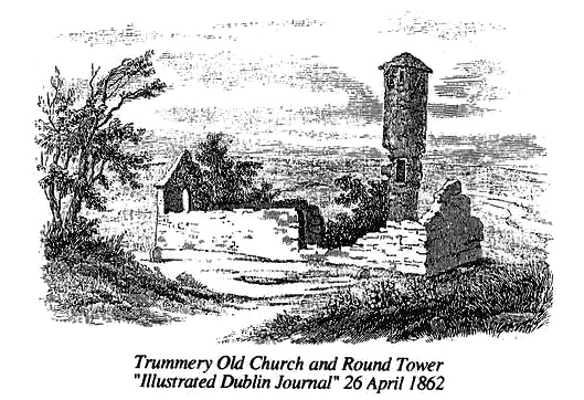 |
Trummery Old Church and Round Tower "Illustrated Dublin Journal" 26 April 1862
The stump of the ancient Round Tower of Trummery and the ruins of the adjacent church are located in a graveyard approximately one and a half miles north-east of Moira, County Down. The ecclesiastical site is situated in the townland of Trummery, which name is a derivation of the Gaelic "tromaun" meaning "a place where elder trees grow", and in the parish of Magheramesk, anciently called Rathmesk
Little or nothing is known of its early history, the only evidence of Celtic origin being the Round Tower, and a document said to date from 1210 contains a possible reference to it. The first definite reference appeared in 1306 when, in Pope Nicholas IV's Taxation Roll for the Diocese of Down, the "Church of Rathmesk" was valued at half a mark (6s 8d), yielding a tithe of 8d. The Diocesan Terrier of 1615 states that the incumbent paid a total of 5s 4d annually, and in 1622 the Bishop of Down, in compiling his inventory of See properties, reported that the church was in ruins. Until well into the nineteenth century, both the church and the Round Tower were consistently plundered by local builders for stone, the accompanying illustration giving some idea of the damage. Today only the west gable and the bottom portions of the church walls survive. A sepulchral chapel built by the Spencer family on to the east end of the church occasioned the destruction of the original and small chancel and is itself now equally ruinous.
The Round Tower, which only survives to a height of six feet, was linked to the north side of the sepulchral chapel by means of a short vestibule. Dr George Petrie and Lord Dunraven, both leading antiquarians in the nineteenth century, were of the opinion that it was erected in the late twelfth century which is late in comparison to most round towers. They based their conclusion on the fact that it was very close to the original church building, this feature being regarded as an intermediate stage in the evolution of the church tower which soon afterwards tended to be constructed as an integral part of the church. An examination of the masonry carried out in 1842 by Edmund Getty, the noted antiquarian and Ballast Master of Belfast Harbour, strongly suggested that the tower was built slightly later than the church.
When entire, the tower stood approximately sixty feet high. A peculiar feature was that it had a rather chunky rectangular base protruding to the south and incorporating a low tunnel-like doorway, above which was the original doorway, set in its customary position eight or ten feet above ground level, the two being connected by a spiral staircase, some steps of which remain. Four windows facing the cardinal points of the compass were located near the top of the tower. The cap which was cupola-shaped was constructed of limestone slabs on concrete, the marks of the wicker form-work still being visible after its fall in 1828. One Mr Rogan, a local antiquarian living in the first half of the nineteenth century, was told by two elderly and respectable men that they could well remember the collapse of a great oak beam in the tower, known as the belltree. Mr Getty's excavations of 1842 also revealed that the tower had been built on top of a small stone-lined burial sepulchre, approximately 6'6" long by 2'3" wide and 2'6" deep, and containing human bones in an extremely friable condition.
Like the church, the Round Tower also served as a local quarry and by the 1820s,
stone from nearly half of its width had been removed from much of the lower
portion. Dean James Stannus, later Rector of Lisburn Cathedral, acting for the
Marquis of Hertford was making arrangements to have the tower repaired, but
unfortunately he was too late, for it collapsed in October 1828. When I visited
the locality in 1969, I heard a most interesting tradition concerning this event
It appears that while a group of farm labourers were working in a nearby potato
field one rather calm and sunny day, there was a sudden and very heavy shower of
rain, whereupon they all took shelter in the tower. It lasted for about half and
hour and ended as suddenly as it had started; the men had not been back at work
many minutes when there was a tremendous crash and the ground shook as though
struck by a tremor. They looked round in time to see the dust settling over a
heap of rubble that had been for nearly seven hundred years the Round Tower of
Rathmesk.
![]()
2. RAM'S ISLAND, CO. ANTRIM
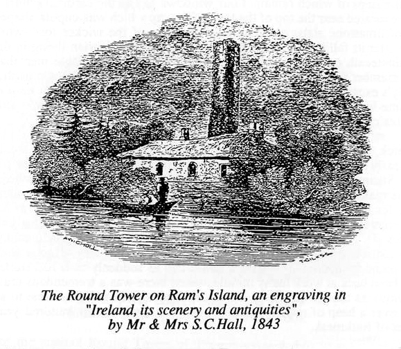 |
The Round Tower on Ram's Island, an engraving in "Ireland, its scenery and antiquities", by Mr & Mrs S. C. Hall, 1843
Ram's Island is the largest of the few islands of Lough Neagh and is located approximately one mile to the west of Sandy Bay, near the south east comer of the Lough, and in the parish of Glenavy. The origins of its present name are largely surrounded by speculation. The earliest known name was Inis-Draicrenn, first used in the eleventh century, and by the seventeenth century this had been anglicised to Ems Garden. Mgr. J.O'Laverty, the eminent antiquarian and historian of the last century, suggested that the present name may have derived from the ending "raicrenn" of the original name being confused in pronunciation with the Gaelic word "reithe" meaning a "ram".
The documented history of Ram's Island is even more scant than that for Trummery. The earliest mention is in the form of a fleeting reference to it in the Annals of Ulster under the year 1056, and again in the Annals of the Four Masters under the year 1121. In the Pope Nicholas Taxation Roll of 1306,"the church of Lennewy (Glenavy) with the chapel was valued at 10s Od yielding a tithe of 12d, and Dr.Reeves, writing in 1847, was of the opinion that "the chapel" was the church of Ram's Island. It is not mentioned in either the Terrier of 1615 or either of the Bishop's reports of 1619 or 1622. However, Speed's map of Ulster, dated 1610, and Johan Blaue's map of 1654, both mark the island as "Enis Garden". and show the symbol of a church tower. It is on record that the ruins of a church were still visible near the Round Tower in the middle of the eighteenth century.
Further proof of ecclesiastical occupation of the site came in the late
eighteenth and early nineteenth centuries when human bones including several
complete skeletons and remains of coffins were occasionally dug up in the
vicinity of the Round Tower. A number of brass fastening pins, probably for
monks' cloaks, were found in conjunction with the burials, and amongst the coins
discovered was one of Edward I. A properly conducted archaeological excavation
covering a wide area around the Round Tower would undoubtedly produce very
interesting and important results.
The most obvious monastic relic is the Round Tower which stands on top of a steep eminence near the east shore of the island. It is constructed from fairly small rounded stones which may well have come from the island's shores, and is forty three feet high, but was probably somewhat higher when it was originally built. The original doorway was about eight feet above ground level on the south side of the tower and is now built up; a more recent one at ground level on the west side was built up in the late 1960s to give the tower extra strength.Two fairly small windows survive further up the tower.
In the late eighteenth century Ram's Island was owned by a fisherman named David McAreavy who sold it for one hundred guineas in 1804. At one time in the last century it was owned by Lord O'Neill who built a charming thatched cottage in the English style, just below the hillock whereon stands the Round Tower, and which can just be discerned in the accompanying engraving. One night not long after the beginning of the Second World War, vandals visited the island and burned down the cottage.
Select Bibliography:
| Dunraven, Lord | Notes on Irish Architecture, 2, V Vol.II, 1877 ed. by M.Stokes |
| Getty,Edmund | The Round Towers of Ulster, c.1857 |
| Joyce P.W. | Irish Names of Places, Vol. 1,5th edition |
| 0'Laverty, Mgr.J. | History of the Diocese of Down and Connor,Vol.II,1880 |
| Petrie, George | Ecclesiastical Architecture of Ireland anterior to the Anglo-Norman invasion, etc., 1845 |
| Reeves, Dr William, | Ecclesiastical Antiquities of Down, Connor and Dromore, 1847 |
| Watson, Rev. Charles | Glenavy etc., Past and Present, 1892 |
![]()
THE CRUMLIN METEORITE
(Edited from various accounts by TREVOR NEILL)
On Saturday, 13th September, 1902 at 10.30 am., a stone coming from the sky struck the earth at the farm belonging to Andrew Walker at Crosshill, Crumlin. The stone was to become known as the Crumlin Meteorite. (1)
The news of the fall spread somewhat slowly, the first notices appearing in the Belfast Evening Telegraph on 16 September and the Northern Whig on the following day. The news had been sent by S R Millar, who had heard at Killead a noise as of an explosion, and had afterwards been to view the fallen stone at Crosshill, where he was given the particulars of its arrival by Andrew Walker. On 20 September, W H Milligan of Belfast, an enthusiastic amateur observer of luminous meteors, went to Crumlin to get more precise information than had yet been published relative to the stone and the phenomena connected with its fall. Having ascertained the details, Mr. Milligan telegraphed Mr. Fletcher, Director of the Natural History Department of the British Museum, who left London immediately and arrived at the farmhouse on the morning of the 6 September. Recognising at once that the stone was undoubtedly of celestial origin, Mr. Fletcher acquired it for the British Museum, and sailed for Liverpool the same day with the stone in his case. The particulars given at the farts to Mr. Milligan and Mr. Fletcher, and a preliminary description of the stone, were published immediately afterwards in Nature, 9 October 1902.
Mr. Milligan, then living in Belfast, was conveniently placed for continuing the inquiries relative to the circumstances of the fall, and for this purpose published in the Newsletter, 26 September and the Northern Whig, 14 October, appeals for information on anything which might throw light on the path of the stone in the earth's atmosphere. He also called attention to the fact that a fall of stone, due to the same meteor, might have occurred elsewhere in the district at the same time, and he addressed special letters of enquiry to railway station-masters and to clergy in the area. Miss A. Black, living at the farm and acting as Secretary in this matter for her uncle Mr. Walker, forwarded to Mr. Fletcher accounts given by those who were near the spot at the time the stone fell. In addition, persons further away, who had heard the noise and afterwards travelled to the farmhouse to see and handle, or inquire about the fallen stone, gave their experiences.
The essential particulars of the fall at Crosshill may be briefly summarised as follows:- At 10.30 am. on 13th September, 1902, W. Walker, M. Montgomery and W. John Adams were at work on Andrew Walker's s farm. Walker and Montgomery were building a stack of hay in the farmyard, the former on the stack, the latter forking the hay from the ground. Adams was only a short distance away, gathering apples beneath a tree near a hedge which separated the farmyard from the cornfield in which he was standing. All three heard a loud noise, (2) but Walker was the only one to catch sight of anything in the air as the stack was nearly finished and he was high above the ground. He stated that after the noise, he saw something like a "whirl" come through the air with the speed of lightning and strike the ground at a spot about thirty yards from the stack, the soil being at once thrown to a considerable distance above the standing corn, then over three feet high and ready to be cut. Adams likewise saw the cloud of dust rising about twenty yards from where he was at work. He immediately ran through the standing corn towards the dust cloud and found that a hole appeared to have been made in the ground. It occurred to him that, if any material body had penetrated the earth, it would have been immediately covered by soil and entered to an unknown and perhaps considerable depth. He therefore hurried to the farmyard to get a spade, and in less than a quarter of an hour from the time of fall, had dug out a black, dense stone, different in appearance from any of the known stones of the district. The stone had penetrated the soil about one and a half feet, at which depth further progress was stopped by an ordinary but much larger boulder in the ground. Regrettably, after it had been dug out, it was impossible, from examination of the hole, for anyone to determine the precise direction in which the stone had entered the earth and thus, the final direction of its path in the atmosphere. According to Adams power, it must have gone straight downwards. That this was the case, approximately at least, is confirmed by an observation by Andrew Walker who, immediately after the fall looked carefully, though without avail, for signs of injury to the standing corn, such as would be expected to have been produced by a dense stone travelling into it at great speed, in a vertical direction.
The stone was hot when extracted, and according to Andrew Walker, was still warm to the touch nearly an hour after it's fall, for which period it had been lying on the window-sill in the open air. Apparently, the morning of 13th September was cloudy, therefore the continued warmth of the object cannot be attributed to the sun's rays.
The Crumlin Meteorite is now a part of Solar history, and can be seen at the
Science Museum, South Kensington. A cast of it is in the Ulster Museum, Belfast.
![]()
COUNTY ANTRIM ROOTS
A member requests assistance from any reader with knowledge of or who has connections with ancestors as per name/place in County Antrim and which approximate in time to dates mentioned:
| Belfast: | Lisburn: | |||
| Bell | 1790-1830 | Alderdice | 1800+ | |
| Hogg | 1800-1860 | Anderson | 1860+ | |
| Bodkin | 1800+ | |||
| Ballymena: | Deveney | 1850+ | ||
| Cameron | 1800+ | Dowling | 1840+ | |
| McBride | 1820+ | Gowdy | 1820+ | |
| Steele | 1850+ | Hill | pre | 1810 |
| Hogg | 1760-1830 | |||
| Ballymoney/Coleraine: | Hunter | 1840+ | ||
| Hogg | 1850+ | Johnston | 1790+ | |
| Steele | 1880+ | Mehir | 1830+ | |
| McBride | 1830+ | |||
| Saintfield: | Parker | 1820+ | ||
| Hogg | 1800+ | Phelan | 1824 | |
| Taylor | 1820+ | |||
| Anywhere: | Watson | 1830+ | ||
| James Cameron | c.1745 | |||
| Lambeg: | ||||
| Connor | 1800+ |
A large amount of information collected from church and GRO records is available
concerning the above and would be gladly exchanged with any person having
similar interests. Please write to: William E. Hogg, 2 Castle Close, Sandycove,
Co.Dublin
BOOK REVIEW
ORDNANCE SURVEY MEMOIRS OF IRELAND
Parishes of County Antrim, Vols.8 (1991) and 21 (1993). Published by the Institute of Irish Studies, Queen's University of Belfast, hb E17, pb E8.75
Two recent books from the Institute of Irish Studies' publication programme are of importance to those interested in the local history of the Lisburn area. The Ordnance Survey Memoirs of Lisburn and South Antrim (parishes of Blaris, Derryaghy, Drumbeg and Lambeg) are contained in Vol.8 while Vol.21 on South Antrim contains the parishes of Aghagallon, Aghalee, Ballinderry, Camlin, Glenavy, Magheramesk and Tullyrusk.
The Ordnance Survey Memoirs arose as part of the creation of the first series
6" maps of Ireland in the 1830s. They provide an account of each parish,
its buildings, antiquities, employment and other topics of local history. They
provide an incomparable picture of local life in an era which was to be altered
irrevocably by the effects of the Great Famine.
![]()